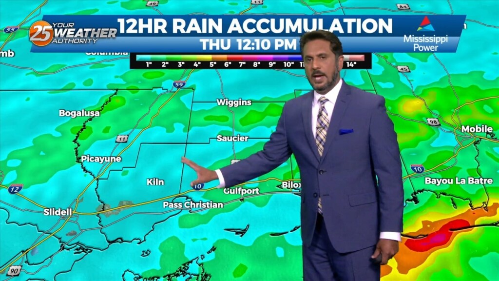
4/27 - The Chief's "Frontal Passage" Thursday Afternoon Forecast
As an area of low pressure continues to drag a cold front through the region, isolated t-storms will continue this afternoon but begin to diminish late afternoon.…
As an area of low pressure continues to drag a cold front through the region, isolated t-storms will continue this afternoon but begin to diminish late afternoon.…
With a disturbance over the Great Lakes, and another disturbance over the northwest, we look to stay in zonal flow for the next couple of days, keeping…
Cloud coverage of the mid-level and upper-level variety has moved in thanks to a disturbance to our west. Clouds and increasing moisture via southerly flow will help…
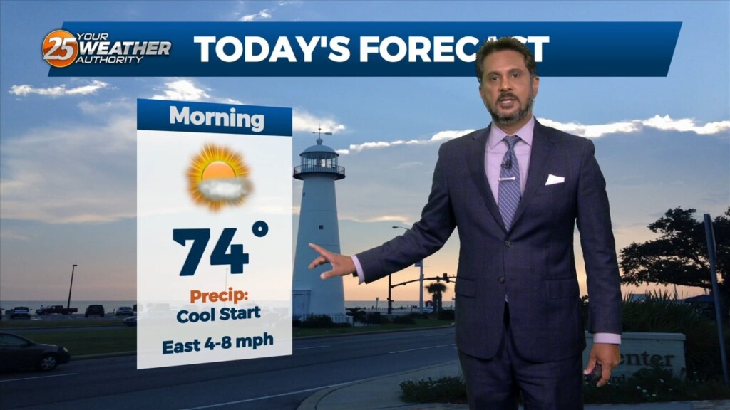
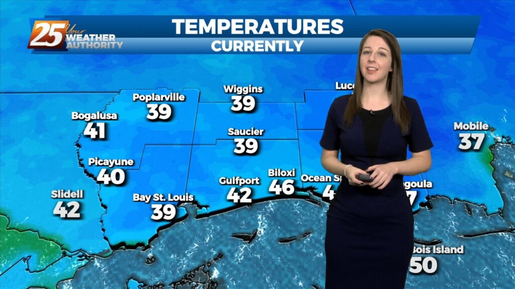
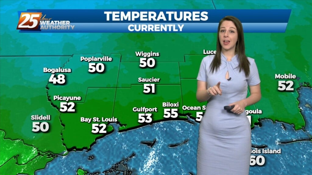
It’s cool, but pleasant this evening. Clear skies and calm-to-light winds will allow for efficient radiative cooling overnight. Temperatures around daybreak will be in the upper-40s to low-50s…
High pressure dominating has lent itself to sunny skies across the region. Temperatures also warmed very efficiently today thanks to dry air and relatively light winds. Temperatures tonight will…

As high pressure will shape the forecast, the next few days is primarily a temps and cloud cover forecast. As the deep closed low continue to…
After a rainy first part of this weekend, the cold front swept through bringing clearer skies with it. Northwesterly winds behind it will continue until high pressure…
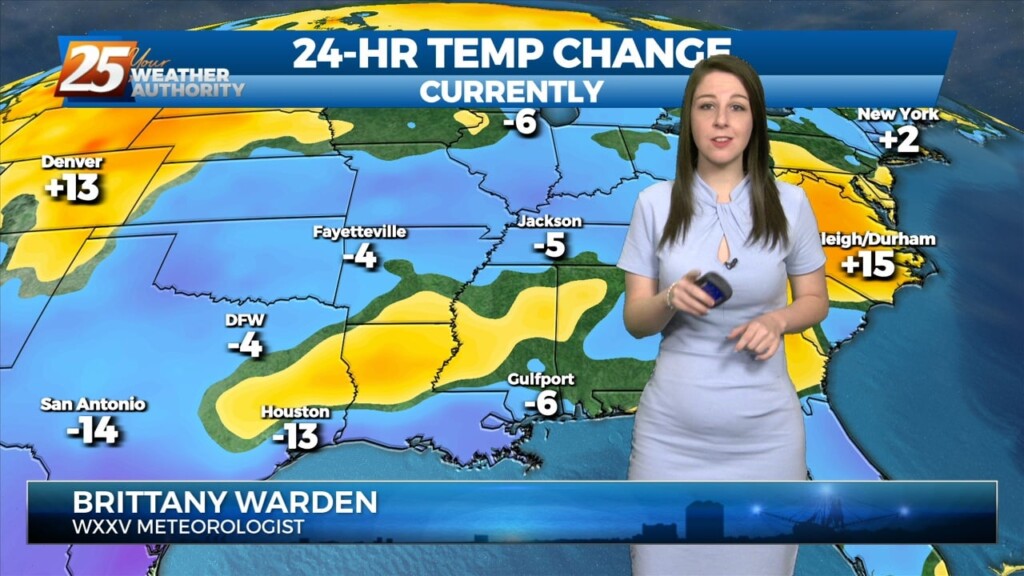
With return flow becoming more established, airmass modification and warming trend will continue tonight with lows a solid 10 to 15 degrees warmer than last night. With low level…
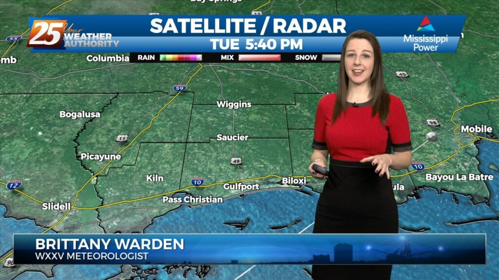
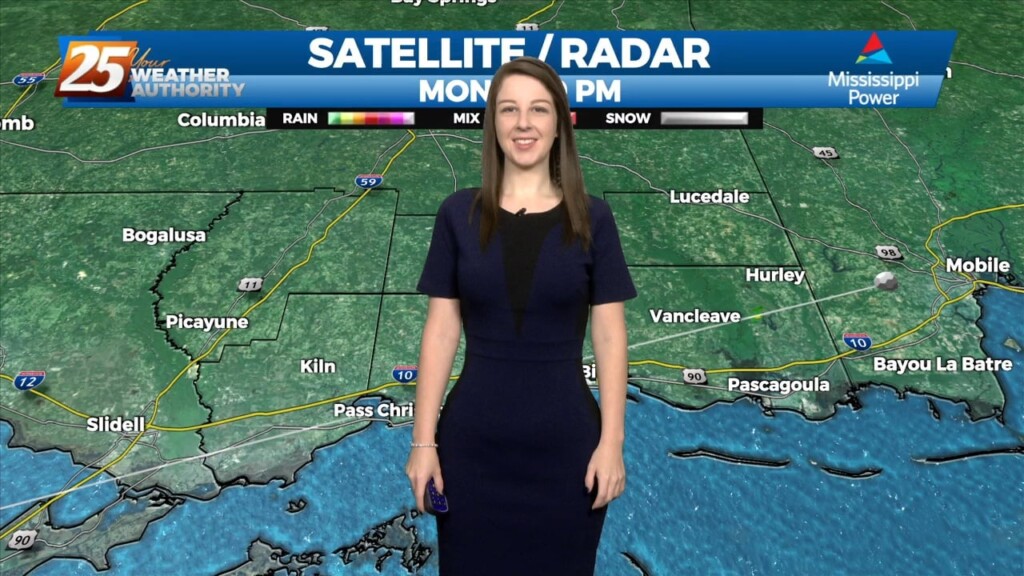
Starting things out this evening glancing at radar illustrates echoes advancing ESE across portions of the CWA. Observations are far and few between reporting -RA but some of this…
Starting things out this evening glancing at radar illustrates echoes advancing ESE across portions of the CWA. Observations are far and few between reporting -RA but some of this…
With high pressure to our east, moisture recovery continues as evidenced by dewpoints now approaching or exceeding 60 degrees in most places across the forecast area. Mostly clear skies…
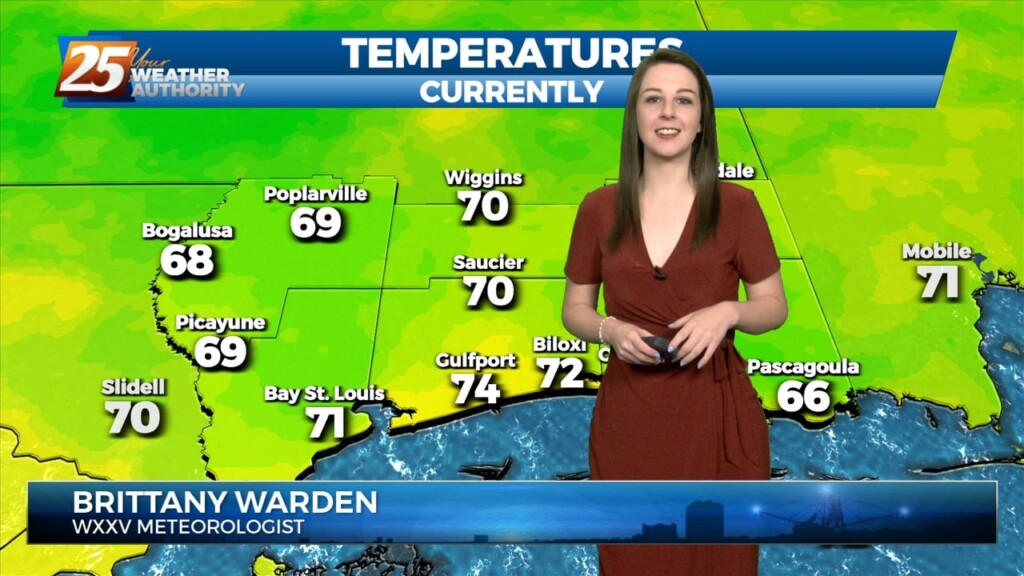
Surface high pressure will continue to shift eastward with onshore winds bringing more humid air into the area from the Gulf of Mexico. Warming trend will continue into Wednesday…
The return flow will become more established today and remain that way through the short term. This will help add to the warming trend over…
One more colder than normal night tonight before the high shiftseastward and temperatures fully moderate. Main forecast challenge for tonight is determining just how cold it will get,…
One more colder than normal night tonight before the high shiftseastward and temperatures fully moderate. Main forecast challenge for tonight is determining just how cold it will…
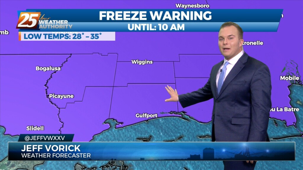
The late season chill will stick around for a little longer across South Mississippi. A Freeze Warning is in effect for all of the Southern Six…
All is quiet now as we await our next weather system. The upper trough is currently over the Dakotas with a weaker shortwave/jet type feature moving across the…
Today will be warmer with southerly return flow developing and slightly higher heights aloft. Mostly sunny skies early will give way to partly to mostly cloudy skies…
Surface high pressure and an upper level ridge dominate the weather for the next couple days. This results in cool, dry air bringing some relief to the warm trend…
Surface high pressure and an upper level ridge dominate the weather for the next couple days. This results in cool, dry air bringing some relief to the…
No significant changes in the overall synoptic pattern that has been influencing the region for the past several day is anticipated through Thursday night. A weak backdoor frontal boundary…
No significant changes in the overall synoptic pattern that has been influencing the region for the past several day is anticipated through Thursday night. A weak backdoor frontal boundary…
The center of the high will pass to our north on Saturday but the ridge axis will move overhead. The high will continue to progress eastward through the…
Current surface analysis shows the cold front has moved east of the forecast area and was near Mobile Bay as evident by the veered westerly winds behind it vs…