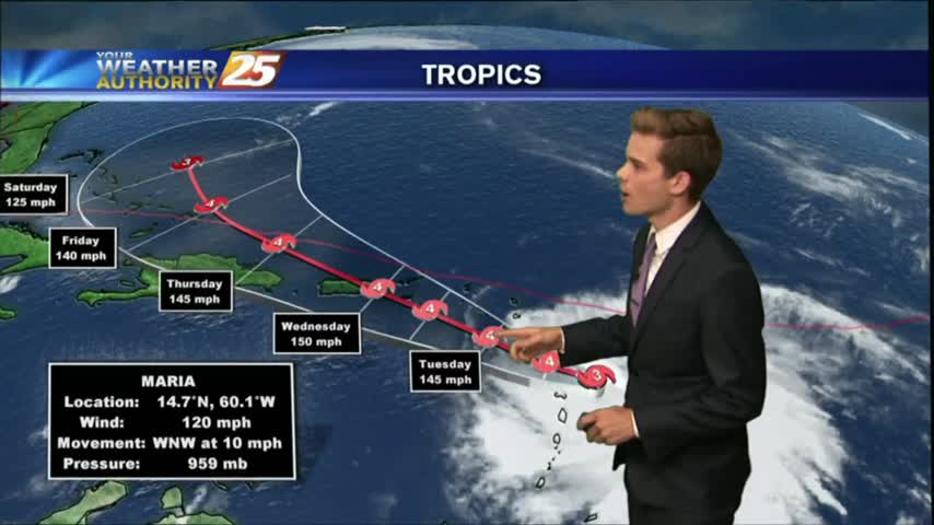
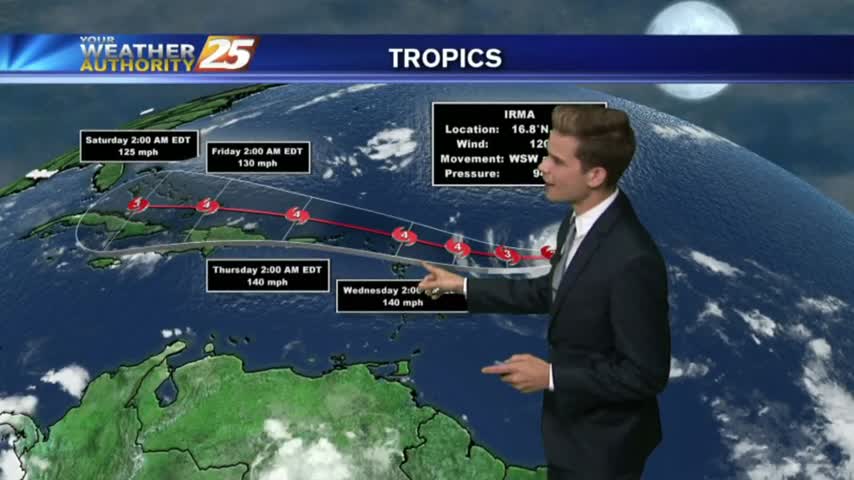
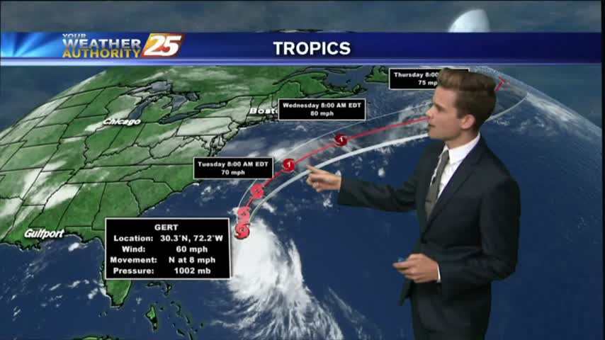
10/9 - Rob's Post Hurricane Nate Forecast
A mild and humid start to the day with rain moving in from the south and areas of PATCHY DENSE fog...

A mild and humid start to the day with rain moving in from the south and areas of PATCHY DENSE fog...
Showers and thunderstorms are starting to develop across the area this afternoon.
We continue to see a few showers and thunderstorms popping across the area as High-pressure centered directly over the Gulf.

A warm/humid start to the day, along with light wind flow has areas of patchy fog along the coastal continues...

It will continue to be humid with temperatures around 90 degrees so take it easy and drink plenty of water if you’re outside for the holiday.
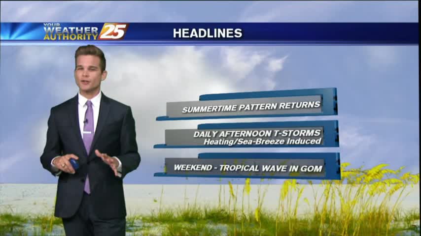
Good morning South Mississippi! I hope you had a great weekend and enjoyed the somewhat drier conditions.
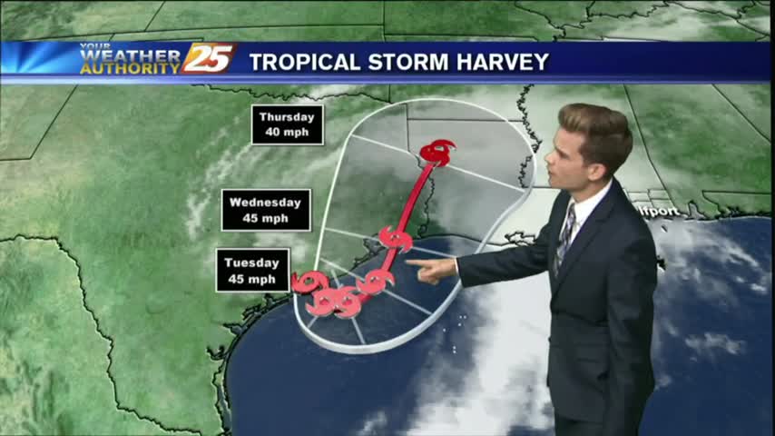
Tropical Storm Harvey will continue to be the main weather feature impacting the forecast through Wednesday as the system slowly moves offshore today and eventually pushes back inland near Houston tomorrow.
The solar eclipse of 2017 has come and gone, but left some neat things to look at! The moisture was on the return into the area today, along with a disturbance in the Gulf of Mexico, which is moving our…
The eclipse will happen from noon until 3:00 pm, but the max eclipse will be at 1:31 pm. Remember to use special solar eclipse glasses to view the event.
Showers and thunderstorms will develop this afternoon because of fairly typical August weather.
Isolated showers and thunderstorms are possible this afternoon.
After a beautiful day yesterday to close-out the weekend, the drier air mass will continue to affect the region through Tuesday, but more rain is on the way.
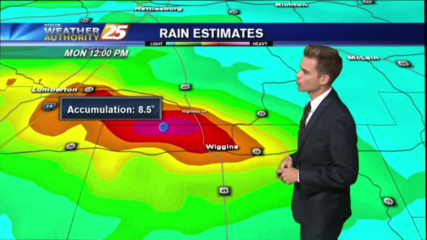
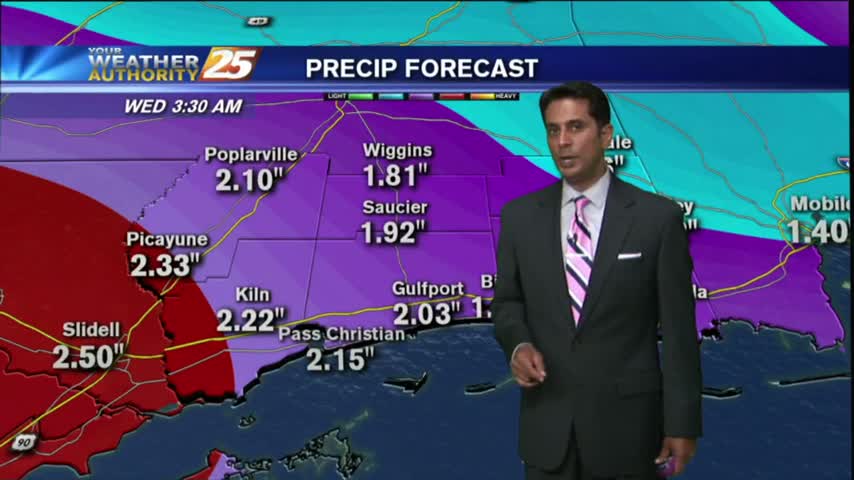
a FLASH FLOOD WATCH continues until 7 pm Tuesday for much of the area.

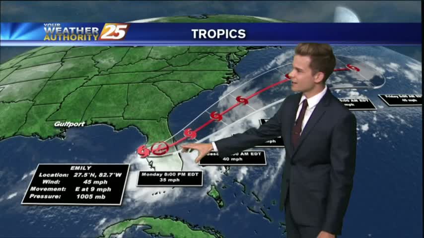
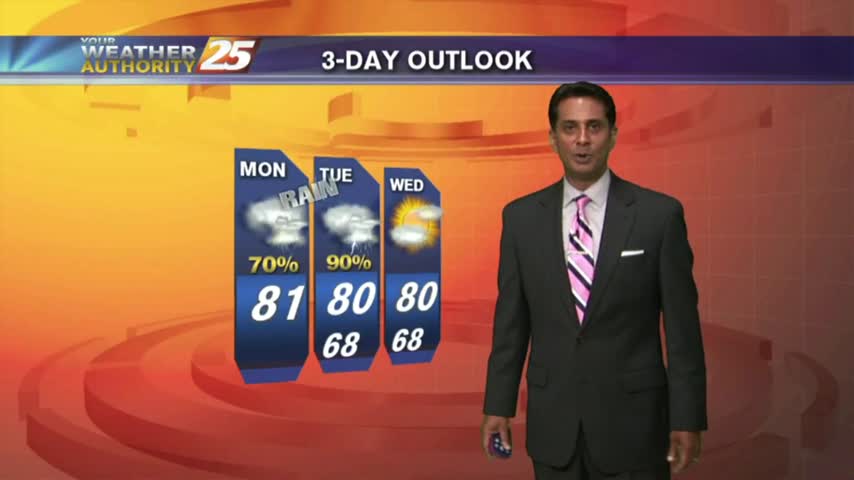
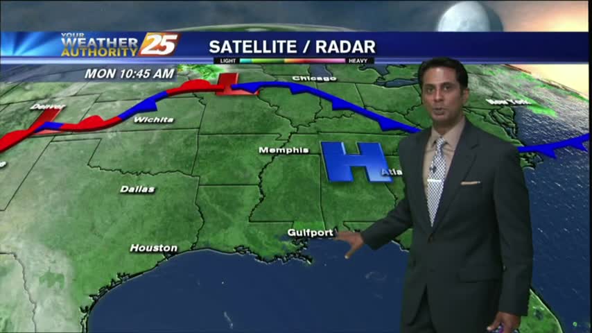
Overnight showers/t-storms continue to affect the viewing area as we kick off the workweek...
Showers and thunderstorms will continue this afternoon and into the night as strong tropical flow continues through mid week as a trough of low pressure in the upper-levels dominate much of the country.
This morning started off dry with a north wind, but south winds have returned to the area this afternoon along with some clouds.

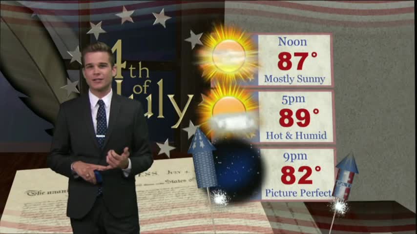
Independence Day will be another day of hot and humid conditions with heat index values running around 100 degrees.
The forecast is stuck on repeat, at least for the next few days.
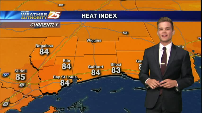
A warm/humid start to the day/workweek with DANGEROUS HEAT INDICES to affect the Mississippi Gulf coast...
A beautiful day in store as drier air continues to filter into the area. With a weak cold front to the south, and high pressure to the north this will continue into Tuesday
Light rain has been moving into the area this morning, scattered showers/t-storms on-tap this afternoon...
After a WET WEEKEND, showers and t-storms will move back into the area later this morning...
After a clear start with patchy fog, temperatures continue to warm with a few clouds developing...
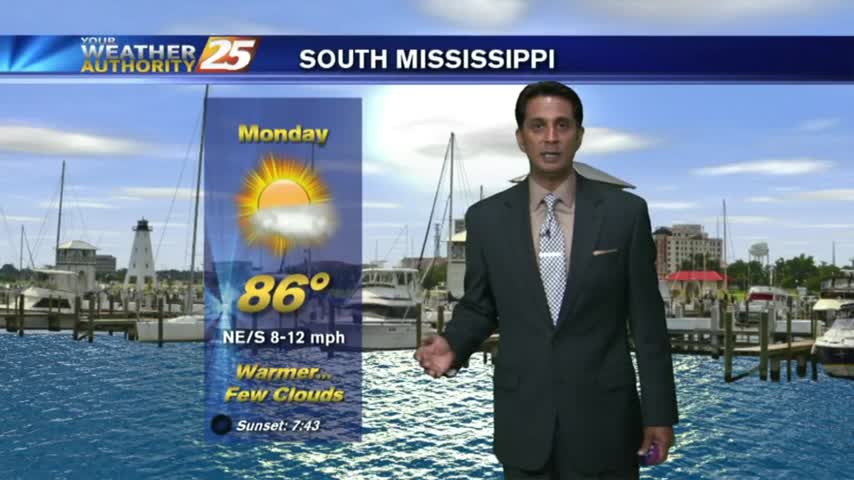
A warm/humid start to the workweek along with areas of PATCHY FOG along the Southern 6...