6/24 - The Chief's "Dangerous Heat" Monday Morning Forecast
The main story today will be the heat as high pressure continues to spread eastward along the Gulf Coast today. Low level moisture will be on the…
The main story today will be the heat as high pressure continues to spread eastward along the Gulf Coast today. Low level moisture will be on the…
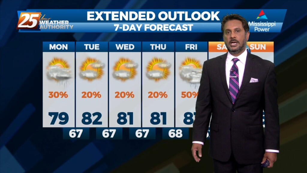
HOT temperatures this afternoon will feel like the low 90s with the heat index! As a stalled boundaries form last week move northward and leave the…
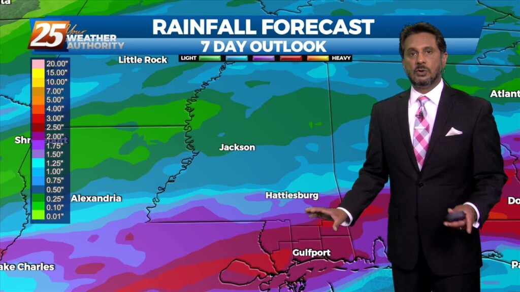
As a stalled boundaries form last week move northward and leave the gulf coast, rain chances will drop off through the weekend. A…
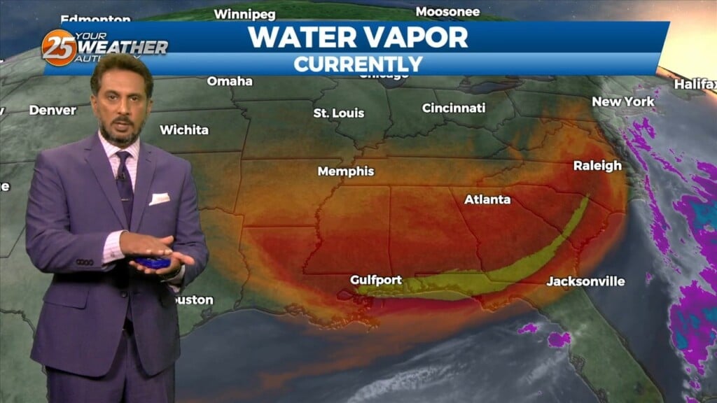
The upper air pattern shows high-pressure extending from south Texas to the Dakotas, with an upper low-pressure centered near Las Vegas. At the surface, high pressure…
Cloud coverage and breezy conditions will increase this morning as an approaching cold front to the west stalls. Early Wednesday we will see a cold front…
No real issues to discuss today. High pressure over the Gulf will continue to dominate the region while low level temps keep slowly stepping up.…
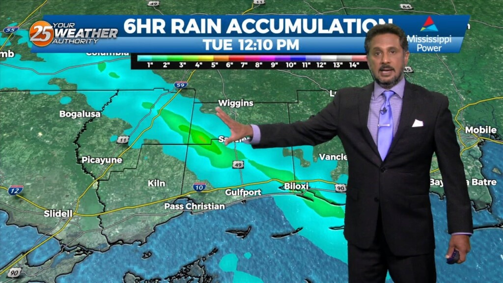
SEVERE & HEAVY RAIN THREAT THIS AFTERNOON/OVERNIGHT... Showers/t-storms will begin around midday with activity increasing this evening and overnight. The next thing would be…
High pressure to our east today will help low level dew points to begin to climb and a slight warming trend (overnight) is anticipated to…
High pressure will continue to build into the region from the west as the low pressure that gave us rain/hail on Sunday continues to move…
This afternoon will bring an abundant of cloud cover, and at least light precipitation. However, current indications are that rain amounts through Tuesday afternoon…
Overall, it’s a very tranquil and "cool" morning across the region with temperatures generally in the 60s with light northerly surface flow continuing. Surface dew-points…
Upper level high pressure is currently entered over the Gulf of California extending northward through the northern Rockies. Weakness extended from the Appalachians into…
Upper high pressure centered near Kansas City this morning, with an easterly wave over the central Gulf of Mexico. Very isolated showers and a thunderstorm or…
A stalled stationary front just north will push south by early afternoon bringing subtle (nice) changes. This will also keep most activity over the marine areas…
With a weak cold front overhead and drier airmass, showers and thunderstorms will pop a little later this afternoon. The activity will get started farther NW and…
An upper-level high pressure that has been parked over the area should break down throughout the course of today. Although the ridge should be breaking…
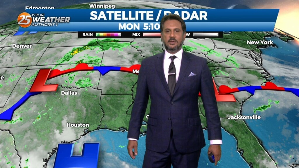
An area of low pressure remains over the Great Lakes this morning, with a disturbance moving into the Pacific Northwest. High pressure was noted over the…

An upper high pressure builds east rapidly, it will flatten an upper trough east of the Rockies and cause it to orient more west to east over…
A meandering frontal boundary currently located just north of the area in south-central Mississippi and central Louisiana will drift southward this morning in response to a…
A warm front moving north this morning over south shore locations could bring enough vertical depth to get some showers out of it today…otherwise just…
Today is a continuation of a steep temperature moderation period that started yesterday as a strong upper level high pressure builds in over the Gulf…
The word for the next couple of days is moderation. As the high pressure shifts off to the east today, winds will come around to the…
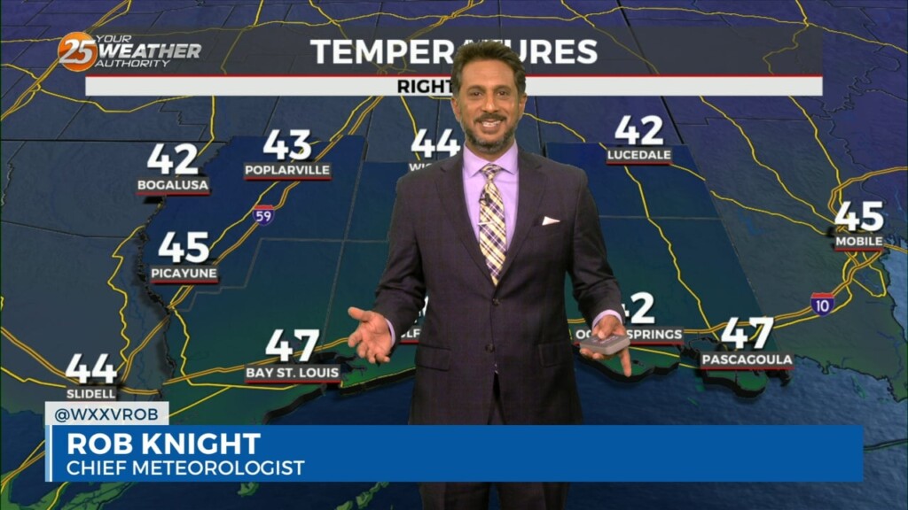
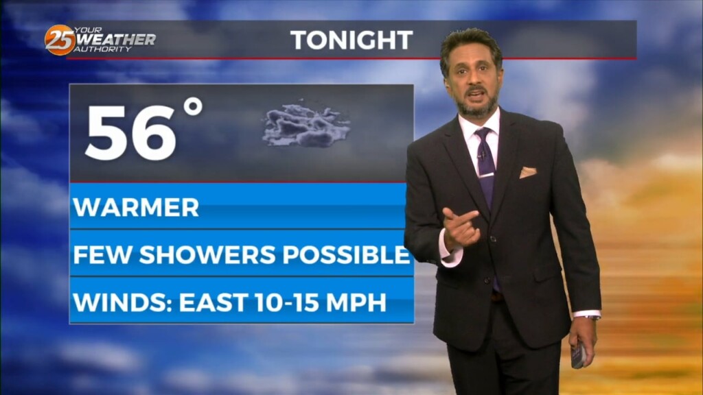
A hard freeze is in store for many of us yet again. Plants, pets, people, and pipes need to be protected with inland temperatures in the 20s.…
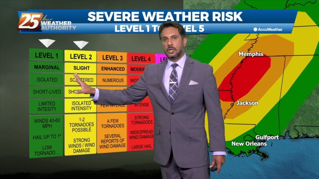
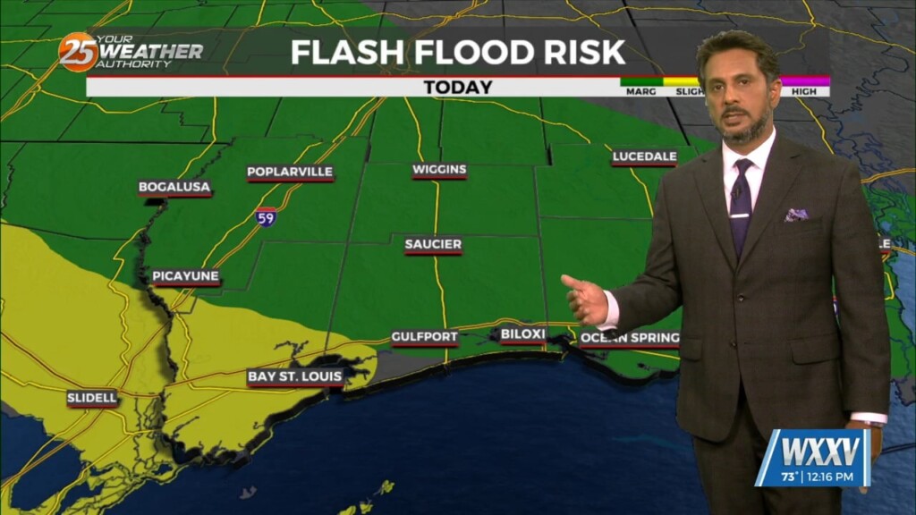
A pleasant day ahead with high-pressure to the NW shaping the short-term forecast. The primary headline to monitor beyond today is severe weather and excessive rainfall potential…