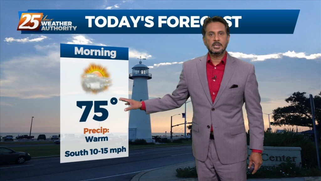
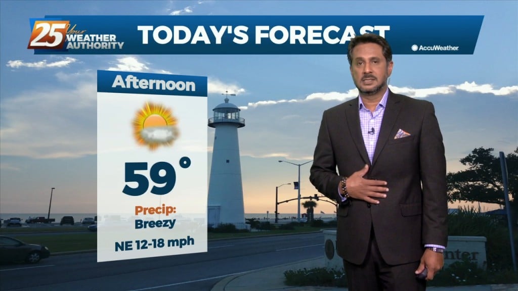
6/21 - The Chief's "Sunny & Hot 1st Weekend of Summer" Friday Morning Forecast
While the low level circulation of former Tropical Storm Alberto dissipated yesterday afternoon, the mid and upper circulation is still evident with…
While the low level circulation of former Tropical Storm Alberto dissipated yesterday afternoon, the mid and upper circulation is still evident with…
Today will bring increasing subsidence through the area.as high pressure begins to expand eastward from the southern Plains and Texas. At most, some fair weather cumulus cloud…
A drier air mass will continue throughout the column bringing rain chances close to zero. As high pressure moves into the region to shape the forecast…
The very weak front has finally settled and now stalled in the outer-coastal waters. The drying throughout the column has been achieved bringing rain chances close to…
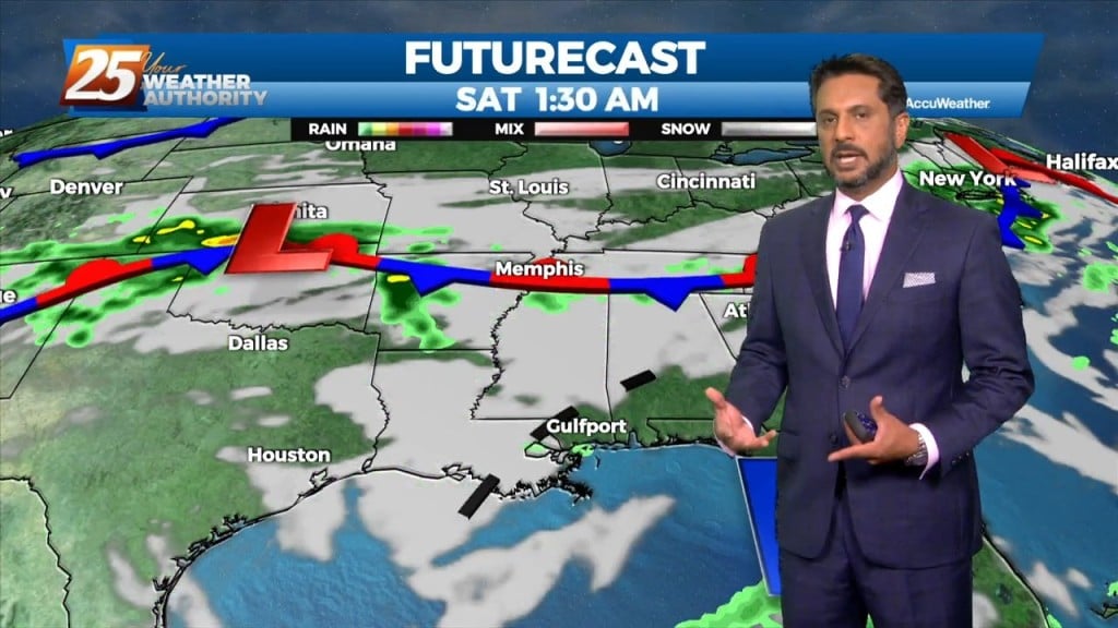
UNSETTLED is the word for the next several days. Heavy rainfall will tapper slowly through the day. Very few severe storms are expected with this…
Today will be a cool day as highs will only get into the lower to mid-50s and this will provide a decent starting point for…

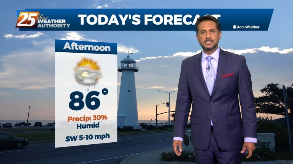
A BEAUTIFUL Friday afternoon ahead with high-pressure to the NW and a weakling stationary front well to the south. Models pinpoint enough moisture above a well-mixed layer…
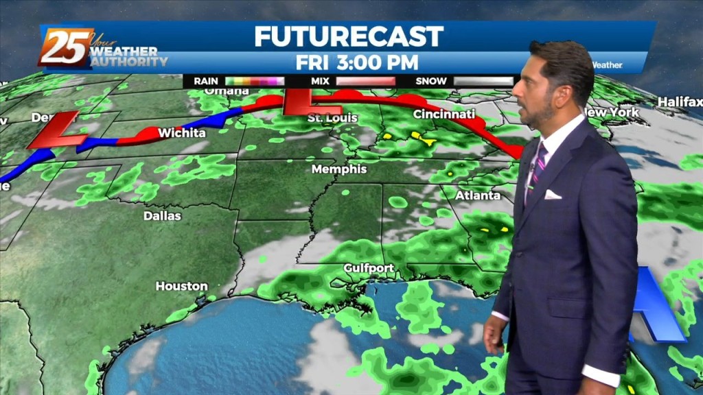
Upper level high pressure continues to spread eastward through the central MS River Valley and into the southern Appalachians. Basically, in a nutshell, same old same old…
A surface, a cold front will slowly move across the area with a nearly solid line of showers and thunderstorms this afternoon. The main…
Early this morning, a strong upper disturbance extended from the Upper Mississippi River Valley southward into Texas. At the surface, a cold front extended from…
High pressure covers much of the Gulf of Mexico, extending northward toward the Great Lakes. A deep upper disturbance extends from Montana to the Four Corners area.…
Sunny skies and windy conditions will prevail this afternoon, with clear and cold conditions overnight. The biggest concern for the weekend is going to be…
Eyes begin to focus to our southwest this afternoon as a coastal disturbance just east of the lower Texas coast begins to sharpen. The…
The same closed mid to upper-level low pressure remains parked over our area, centered generally over SE LA. The same corridor of deeper moisture continues along progressive…
Through the end of the week, an upper level low is expected to influence the area, enhancing rain chances for the region. There are still some…
The upper high pressure over Colorado this morning will gradually build southeastward over the next few days, even as the trough to our northeast continues to dig…
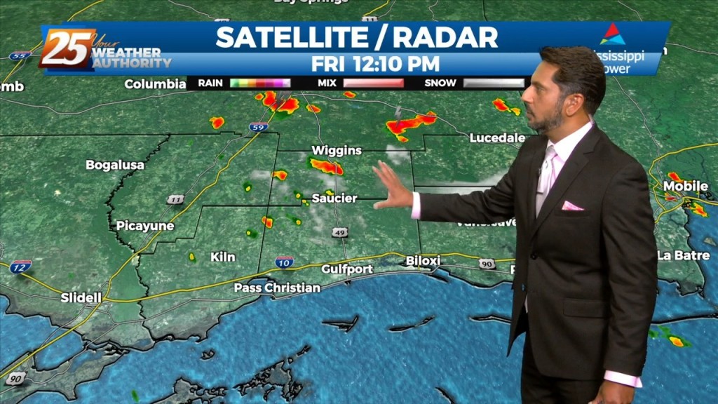
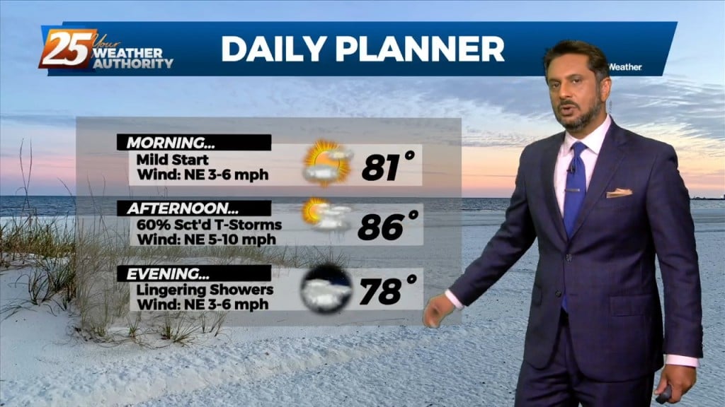
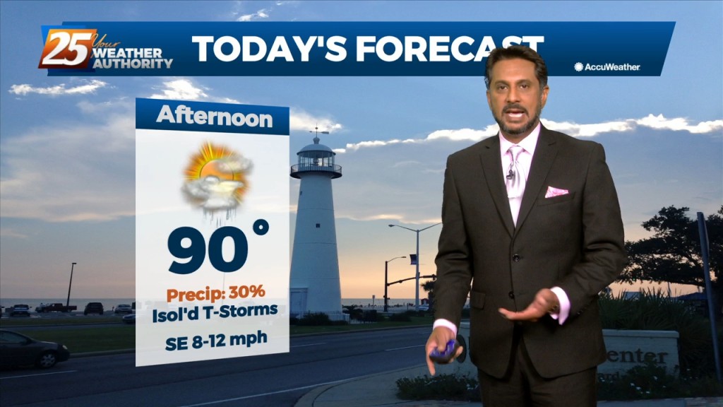
This afternoon will bring hot temperatures and a few showers/t-storms induced by the sea-breeze. Activity will fizzle out just before sunset. With an uptick in mid-level drier…
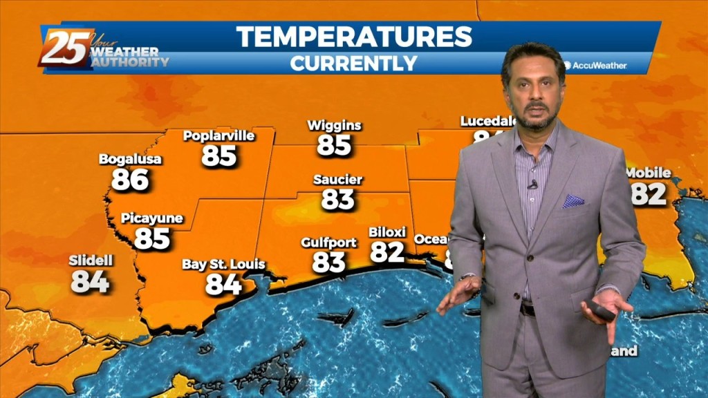
Today will bring hot and humid conditions with t-storm coverage slightly more reduced for generally areas along/near of I-55 and east to the MS coast given…
Scattered shower/t-storms this afternoon will see a gradual transition of dry air replace deep moist air this weekend. Then another transition of this dry air to…
Today won’t be very different from the last several but there are some minor changes on the way. We should see a gradual transition of dry…
Today through Sunday a broad upper level high pressure will be centered near the 4-corners region extends from Mexico to Canada and CA to around MS.…
Southerly surface winds will help to advect moisture and warm air into the environment. There will still be plenty of moisture in the atmosphere and moisture…
The hot and dry pattern will come to and end this weekend... The upper pattern will start the transition into a wetter one late in the…
As high pressure to the east moves further east, southerly return flow has commenced below about 10,000ft. This could produce a few showers or perhaps a thunderstorm…