05/10 Ryan's "Muggy" Monday Night Forecast
Another warm, humid, and wet start to the week, though it will finish much more on the dry and sunny side as last week did....
Another warm, humid, and wet start to the week, though it will finish much more on the dry and sunny side as last week did....
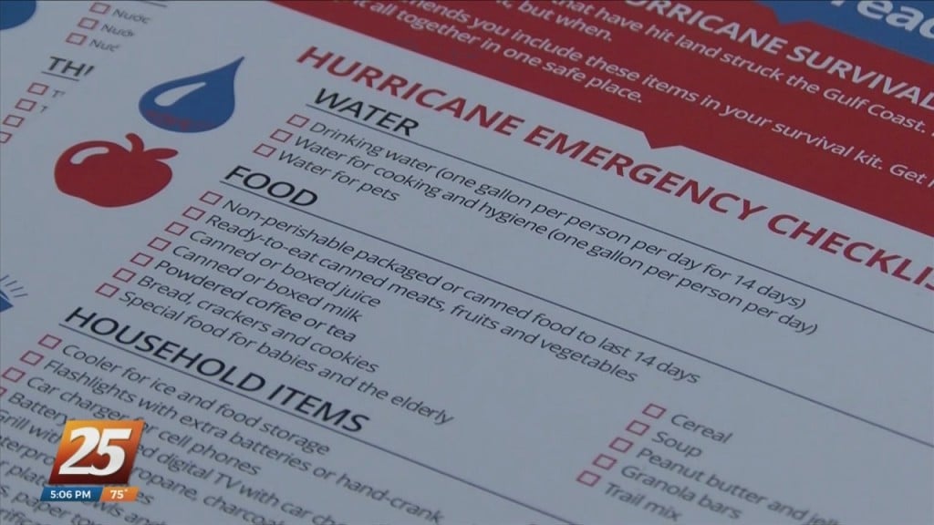
It’s going to be an active hurricane season according to Harrison County EMA Director Matt Stratton. It’s Hurricane Preparedness Week and here are a few tips to keep you and your families safe ahead of the…
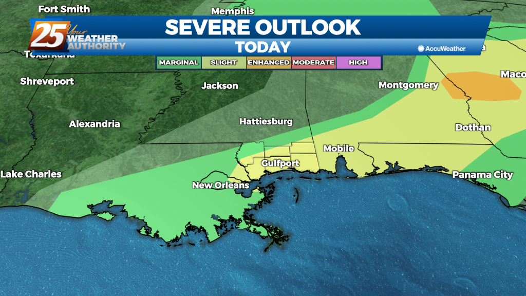
There will also be a limited risk of an isolated severe storm forming over the next couple of days. The latest rainfall forecast in the near term has trended downward about one-half inch area-wide. While we still…
There will also be a limited risk of an isolated severe storm forming over the next couple of days. The latest rainfall forecast in the near term has trended downward about one-half inch area-wide. While we still expect widespread rainfall…
We're heading into a nearly perfect weekend after an amazing end to the week, but sadly it won't last forever....

After a very wet and active weather pattern, we will jump right into a drier pattern through the rest of the week and upcoming weekend. Beginning with early this morning, a recent cold front has delivered slightly cooler/less humid air…
It has been quite humid for the last few days, but slightly cooler and drier air is moving in just in time for the weekend.

Based on the latest high resolution models, it will likely to take another few hours for this system to shift south and east to push thunderstorms far enough offshore to relax the flash flood threat across significant population areas. The…
First line of storms passed through without any severe weather and the threat has diminished, but we'll still see at least a few thunderstorms through the night.

Due to the threat of severe weather, offices on both the Hattiesburg and Tradition (Biloxi) campus will close at 3 p.m. today. Night classes will not meet on either campus.
Two major segments to the forecast through Wednesday will be the possibility of severe thunderstorms and the potential for flooding rainfall. Excessive rainfall could occur as the cold front slows to a crawl and provides a focus for redevelopment over…
Slightly cooler and drier over the weekend, but we're right back where we started with lows in the mid 70s and patchy morning fog....

Severe storms moved through parts of Mississippi Sunday. Cleanup is underway in Yazoo County where a tornado passed through yesterday. Multiple homes along Witherspoon Road suffered damage. Strong winds split trees in half and sent debris scattered throughout yards.…
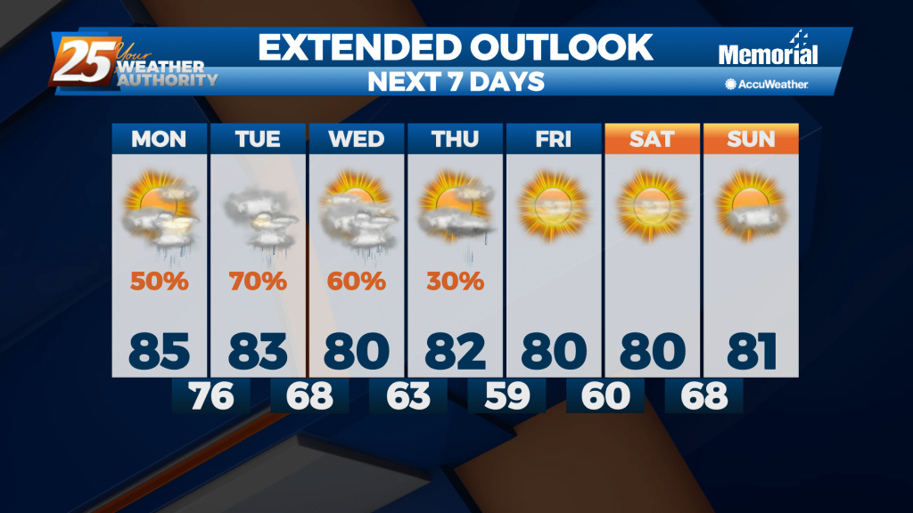
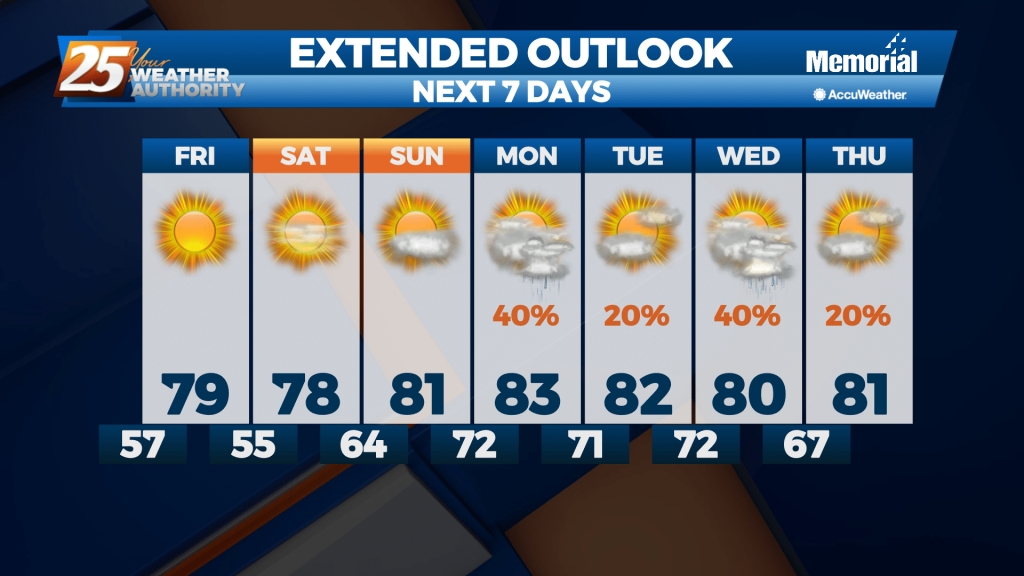
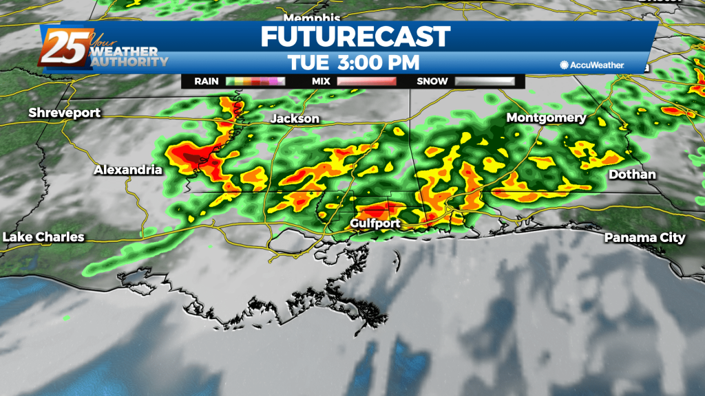
Daytime heating with highs forecast to be in the mid to upper 80s should be enough to fire up some isolated to scattered showers and thunderstorms Monday afternoon. The next significant round of storms comes into the area Tuesday. As…

Daytime heating with highs forecast to be in the mid to upper 80s should be enough to fire up some isolated to scattered showers and thunderstorms Monday afternoon. The next significant round of storms comes into the area Tuesday. As…
Finally saw our rain moving in earlier today, and now the clouds will slowly clear through the night as things cool and dry....

As a weak cold front moves across the region today and momentarily stalls near the coast during the day, rain chances will increase to around 50 percent. Moisture pooling along the front across our coastal areas in combination with surface…
We've gotten as warm as we're going to this week as the thermometer begins to fall in the days ahead. It just won't be by very much....

As the weak front slowly moves through the area, this will support slight chance to a good chance of rain returning to the area late Thursday night and Friday. Lows tonight will be mostly in the mid 60s with patchy…
Another warm, humid night ahead as moisture continues to pile up ahead of an end-of-week front.

Today we’ll see clouds continue to roll in from the west as temperatures heat up to the upper 70s and lower 80s for highs. Rain chances stay low today but there is a good chance slight rain chances will return…
Another foggy night ahead as a slow moving front piles up moisture in the South MS area, with little change until the weekend.

High pressure continues to dominate the southeastern U.S. through Wednesday night, giving us calm conditions with little to no chance for rain. Our high pressure system shifts east into Wednesday and Wednesday night as a low pressure system slowly shifts…
Didn't dry much after our weekend front and now the humidity will slowly rise for most of the week, so get ready for some muggy, foggy evenings....