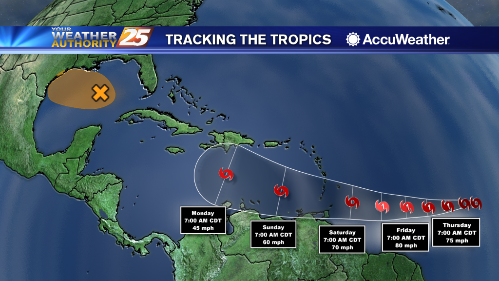
05/05 Ryan's "Hotter!" Tuesday Evening Forecast
Much hotter today, but some slight relief is on the way as a front moves through.
Primary Menu
About
Connect With Us
Much hotter today, but some slight relief is on the way as a front moves through.
As we continue with Hurricane Preparedness Week, today’s theme is about assembling disaster supplies. Even though we are dealing with COVID-19, it’s important to think about your plans and refreshing your supplies. Things are a bit different this year as…
Highs today will get up to the mid 80s under mostly clear skies. Overnight, cloud coverage will increase slightly as temperatures stay mild, only dropping to the mid 60s on the coast and lower 60s for inland areas. Rain chances…
The disturbance diving through the southern Great Lakes States will push a cold front through the area this evening. Expect isolated to scattered t-storms to develop in advance of the front. The majority of activity in our region will be…
The weather will remain nice, but heats up tomorrow before a slight cool-down and some end of week rain.
The humidity and temperature have been slowly rising through the weekend, but will rise sharply tomorrow before a slight cool-down.
MEMA is urging all Mississippians to begin their preparations for the upcoming hurricane season. May 3rd through May 9th is ‘National Hurricane Preparedness Week.’ The Atlantic hurricane season begins on June 1st and ends on November 30th. This year, MEMA…
Overnight lows will be in the upper 50s on the coast under clear skies. Monday’s highs lift to a range from 85 to 90 north of I-10 while the more southerly flow over the coast favors keeping highs along the…
Dry air will linger a little longer before things get humid on us again, just before another front moves though.
Happy first of May everyone! The beautiful weather is in no hurry to leave, so be sure to enjoy it before those muggy conditions return.
Comfortable levels of humidity will remain in place for the rest of the week, but it does begin to get a bit muggy by the start of the next.
If you liked today, there isn't much you won't like about the rest of the week and most of the next....
Thursday through the weekend, skies will be sunny with just a few upper-level clouds rolling through. High temperatures today will be in the upper 70s, gradually increasing to the mid 80s over the weekend. By early next week, temperatures will…
Dry high pressure has settled east of the continental divide and will remain in place for quite a while. Initially centered along the NW Gulf Coast, will migrate eastward slowly and park over NE Gulf Coast over the weekend into…
Cold front brought strong storms early this morning, but is now bringing much cooler and eventually much drier air into South MS.
Had a stormy start to the day, but cooler drier air will slowly move in for the rest of the week.
The severe weather threat has come to end across the Gulf Coast, but showers will continue to pop up on and off throughout the afternoon. Rain will eventually move out of the area late this evening and skies will quickly…
High rain chances will continue this morning with showers and scattered embedded storms along the front. A few strong to severe storms in this squall line are expected with hail and strong to damaging wind gusts being the main factor,…
A small convective system brought a few thunderstorms before midnight, but we'll see the strongest activity with this frontal system move in tomorrow morning.
They dry conditions haven't helped in regards to the Canal Road fire, but the humidity is slowly rising and rain is expected overnight and tomorrow.
Sunny, dry conditions will continue through Tuesday afternoon. Winds are blowing out of the southeast at 10 to 20 miles per hour, with gusts up to around 25 miles per hour. Those winds are bringing in more moisture, but what…
Clear, calm, and cool tonight, but things heat up again tomorrow and the dry conditions won't help the wildfire in Harrison County.
Our beautiful weather isn't helping firefighters battle the blaze in Harrison County, but at least some rain is on the way.
High pressure has settled into the area, creating calm conditions for most of the Gulf Coast. Generally clear skies are expected with northwesterly winds through mid-week. There will be a brief window late Tuesday night and Wednesday morning, just ahead…