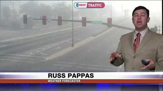
A Dense Fog Advisory through Wednesday morning
A Dense Fog Advisory is in effect for our coastal counties through 10 a.m. Wednesday.

A Dense Fog Advisory is in effect for our coastal counties through 10 a.m. Wednesday.
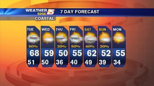
Partly cloudy overnight with areas of patchy fog, southeast winds at 5 to 10 mph and lows in the mid-50s.

Isolated rain will be possible tonight under cloudy skies with lows in the lower to middle 40s. Mostly sunny tomorrow with highs near 60.

Mostly clear tonight with lows in the mid-30s. Winds will be from the west at 10 mph.

Mostly cloudy tonight with lows in the lower to middle 30s. Mostly sunny tomorrow with highs in the mid-50s.

Rain likely tonight with as much as one to two inches possible and lows in the lower 40s.

Cloudy with rain likely tonight and lows in the upper 30s to lower 40s inland and lower to middle 40s along the coast.
Scattered showers tonight with lows in the middle to upper 30s inland and upper 30s to lower 40s along the coast.

Mostly cloudy tonight with lows falling into the upper 20s to lower 30s inland and lower to middle 30s along the coast.

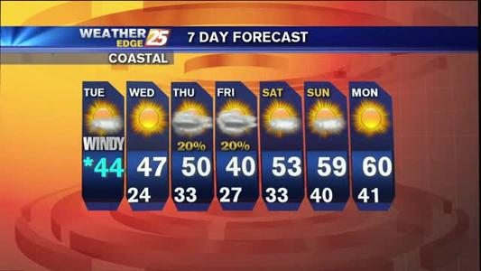
Partly cloudy and breezy tonight with lows in the lower to middle 30s.

A Dense Fog Advisory is in effect until midnight for coastal counties. Expect areas of dense fog, scattered showers and storms and lows in the middle to upper 40s.
Cloudy with a slight chance for isolated rain and lows in the upper 40s to lower 50s. Areas of patchy fog will be possible overnight into Tuesday morning.

Expect mostly clear skies tonight with lows in the middle to upper 30s. Areas of patchy fog will be possible.

A wintry mix possible for the beginning of the night, then cloudy with lows in the upper 20s.

A Hard Freeze Warning is in effect until 11 a.m. Friday. Expect freezing temperatures for a 12 to 15 hour period and conditions to reach hard freeze criteria for 5 to 8 hours.
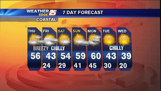
Sub freezing temperatures are to be expected along with breezy conditions and subsequent wind chills that will keep things blustery and frigid.

Clear skies overnight with lows in the upper 20s to lower 30s. Partly to mostly cloudy tomorrow with highs in the mid-50s.
A reinforcing shot of winter is moving toward South Mississippi and this should keep your heavy coats, hats and gloves at the ready.

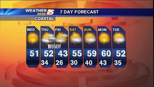
A Hard Freeze Warning is in effect from midnight until 8 a.m. Wednesday for Pearl River, Hancock, Harrison and Jackson counties. Expect lows to fall into the lower to middle 20s with wind chill temperatures into the teens for some locations.
Active weather pattern will bring strong wind speeds and freezing temperatures to South Mississippi twice this week.
Mostly cloudy tonight with lows in the middle to upper 40s. A few areas of isolated showers/drizzle will be possible.
The winter window will be open for chilly temperatures, strong wind speeds and even a few opportunities for rain showers this week.
Clear skies overnight with lows in the middle to upper 20s inland and upper 20s to lower 30s along the coast.
Clear skies overnight with lows falling into the upper 30s to lower 40s along the coast and middle to upper 30s inland.