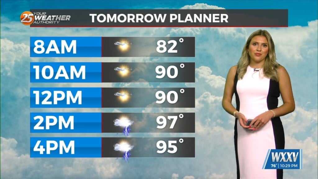
4/3 – Rob’s POTENTIALLY “Severe Threat” Forecast
Stratus deck holding steady as it moves in this morning at 500-1000`. This will lift and break up but skies will remain partly to mostly cloudy. The cold front should begin to move through the area around midnight tonight with showers/t-storms just ahead of it. There could be a section of showers/t-storms that race out well ahead of the front as it approaches extreme southwest Mississippi. This section of showers/t-storms could produce some strong linear wind speeds. Any thunderstorm activity that is produced along this wind shift line could cause damaging wind speeds. This will be the main hazardous variable associated with this front. Even though tornadic and hail variables are not impressive, there is just enough energy with this system that we cannot negate the chance of these occurring as well. SPC continues to keep most of the area in a slight risk of severe and this looks very appropriate.
The front`s southern end begins to feel the effects of a building mid-level ridge to the southwest as the front moves into the gulf. This will start to cap the southern end of the front as it moves into the gulf causing a slow decay of strong and severe probabilities and overall coverage of showers/t-storms as well.
Another cold front is projected to move to the coast or just offshore by the weekend. Models are having a hard time with the placement. But regardless, the front will stall once it gets around the coast. This boundary will help keep the atmosphere unstable enough for a few showers/t-storms to develop each day until a new front arrives for the start of the new week to force all this southeast.


Leave a Reply