2/3 – Rob Knight’s “Threat For Heavy Rain” Thursday Morning Forecast
A cold front west will slowly move east and through the area this evening. This afternoon will bring the biggest potential for impactful weather to the local area. Thunderstorm initiation will be coming mid/late morning across southeast LA then early afternoon in south Mississippi. The area is under a “Marginal” threat for SEVERITY, with strong winds and small hail being the main threat. In addition to the severe weather threat, heavy rainfall will also be a possibility. This will likely be on the tail end of the severe potential early/late afternoon as the individual cells become more linear in coverage.
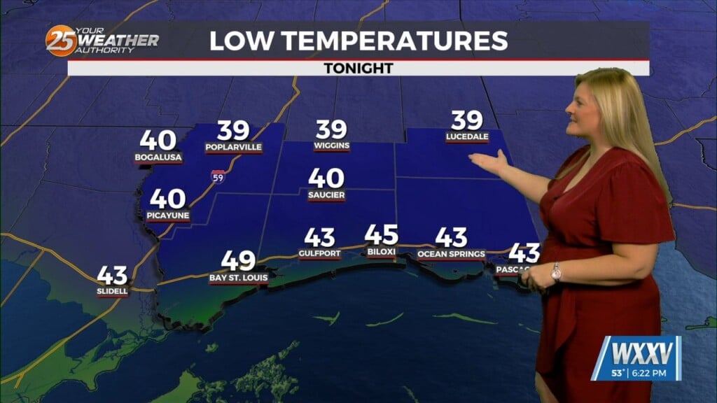
As the stronger storms and heavier rain shift south/east this evening with the front moving through, over running precip will persist through much of the night. Rain looks to be cleared out well before any real cold air reaches the area. Then, after a mid-70 degree day today, Friday will be drastically colder with highs barely topping 40 in some northern area locations.
By this portion of the forecast period, the cold front should already be in the northern Gulf of Mexico. Post frontal lingering showers Friday morning and rain ending from NW to SE as the day continues. Drier air mass will filter in across the lower Mississippi River Valley Saturday and Saturday night.
Leave a Reply