10/27 Ryan’s “Enhanced Risk” Wednesday Evening Forecast
Our severe risk was upgraded to "enhanced" earlier today as a strong front pushes through.
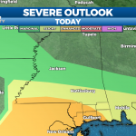
The severe risk today rose from level 2 (slight), to level 3 (enhanced) earlier today. This is due to the strong front moving in with a decent low level jet, that can create rotating storms. The chances of seeing tornadoes is still fairly low due to the structure of the storm, but they could still be embedded within the line.
The threat will last from now (around 6:30 PM) until just before midnight, though conditions will rapidly improve after.
By sunrise, expect a similar low to the last few nights near 63, with breezy winds from the west. Those breezy conditions carry over into tomorrow as well, with a much cooler, drier high near 73 with sunny skies. There will be a few upper level clouds to the north as the low breaks down, but no more rain. In fact, short of a few little impulses that’ll bring a few clouds from time to time, it’ll remain sunny and drier for the about the next 7 days! Another, weaker front begins to move in by next Wednesday which brings our first chances of clouds and active weather since tonight.