windy
4/2 -Sam Parker's "Wow It's Windy" Wednesday Night Forecast
Strong winds Wednesday and Thursday with warm and muggy air across south Mississippi. Continuing to see warm air overnight with lows in the lower 70s. Thursday…
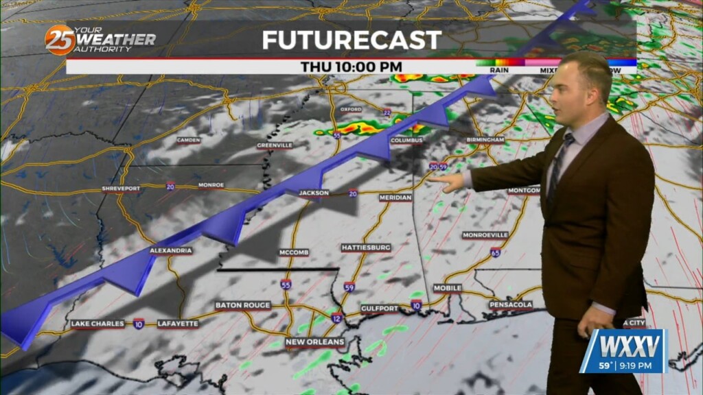
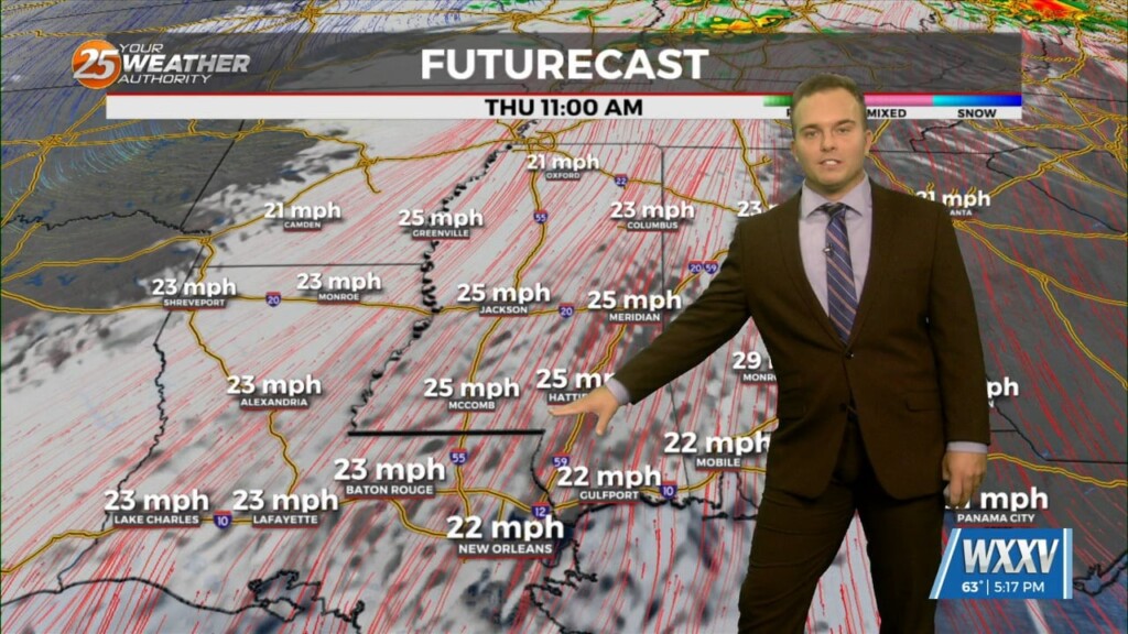
9/26 - Sam Parker's "Windy and Cool" Thursday Midday Forecast
A cold front that continues to push south and east into the Gulf of Mexico this morning. This front, moves drier air into the region, which…
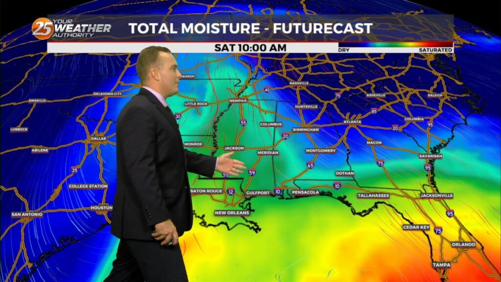
6/18 - Sam Parker's "Bad Hair Day" Tuesday Evening Forecast
High pressure to the NE appears to strengthen a bit and move back over the next few days. This suppresses the circulation to the southwest enough…
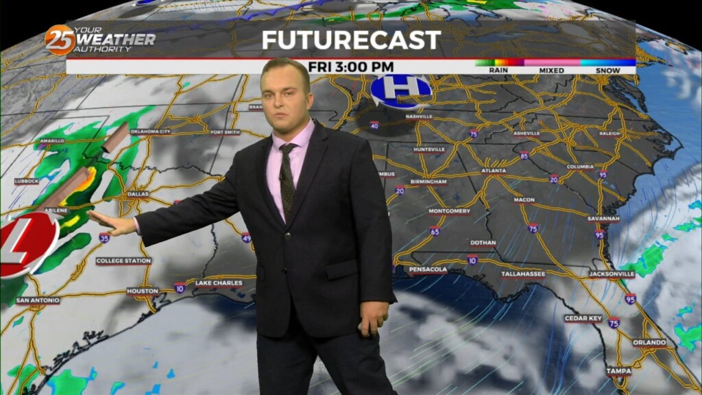
3/22 - Jeff's "Final Shows, Thank You Mississippi Coast Viewers!" Friday Night Forecast
A 20-30% chance of showers cannot be ruled out tonight but any rainfall will be quick in nature. A cold front works through…
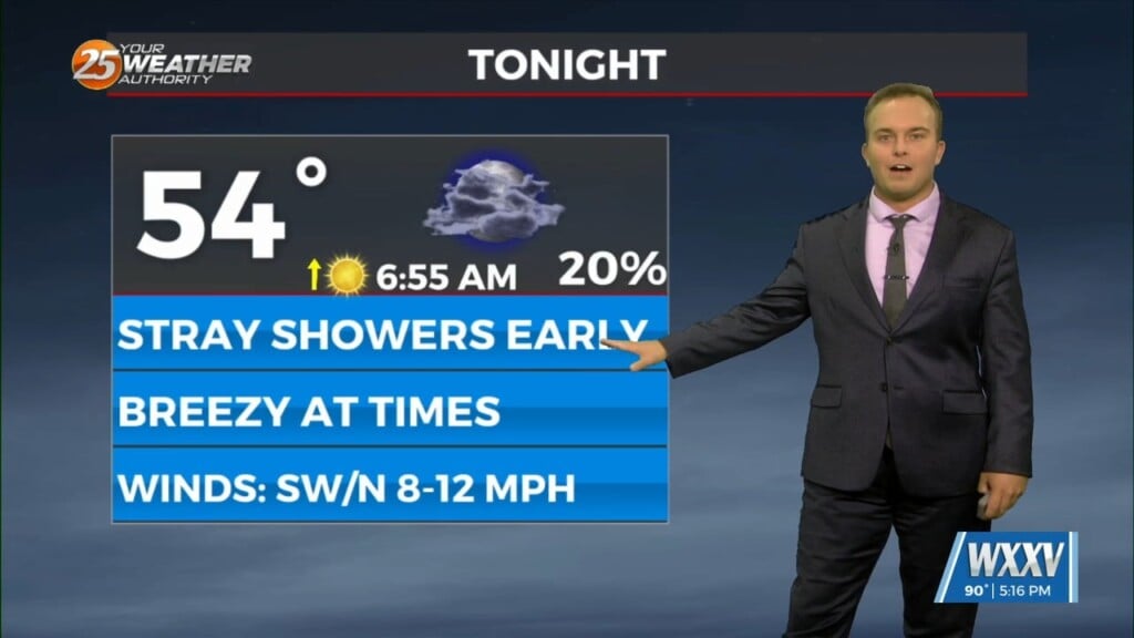
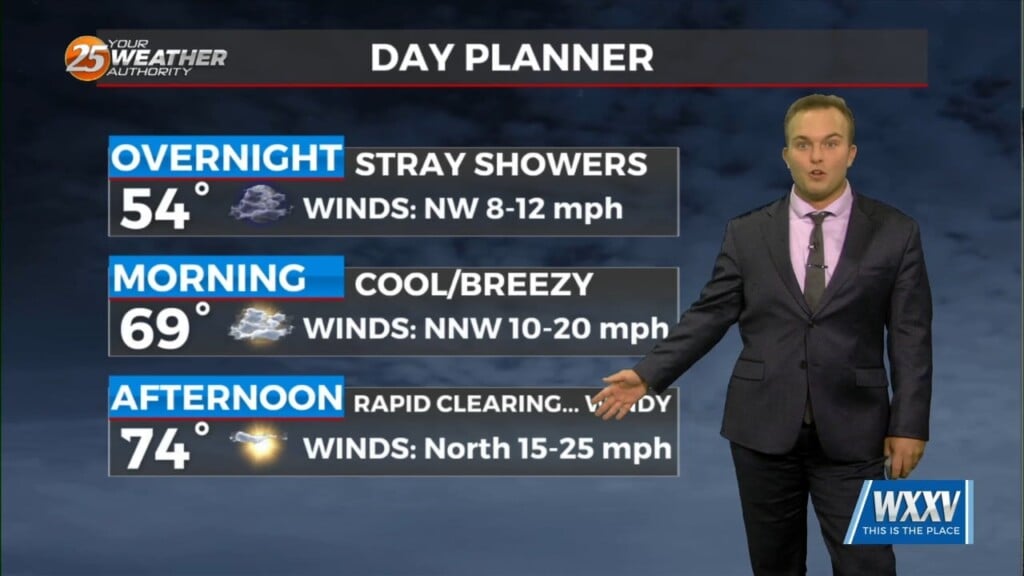
3/22 - Jeff's "Stray/Isolated Rain Chances" Friday Evening Forecast
Low pressure in the region will help provide for rain chances this evening and overnight with quick-hitting showers. Saturday brings rapid clearing and gusty winds but a…
2/21 - Jeff's "More Clouds/Rain Chances" Wednesday Night Forecast
Clouds increase ahead of the start of your Thursday morning. Fog should not be a widespread issue again but some spots may have light patches of it.…
2/21 - Jeff Vorick's "Mild" Wednesday Evening Forecast
A fairly comfortable one is on tap this evening and temperatures will be fairly mild overnight. Clouds will increase after midnight and while fog is not a widespread…
2/12 - Jeff's "Some Clearing/Gusty Winds" Lundi Gras Afternoon Forecast
A cold front moved through the area this morning which brought an end to the rainfall. This afternoon, some sunshine will emerge but the main concern…
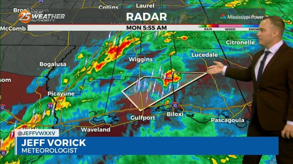
2/12 - Jeff Vorick's "Rain/Severe Threat Ends" Lundi Gras Morning Forecast
The threat of severe weather will come to an end this morning and the Tornado Watch for Stone, Jackson, Harrison, & George County will be…
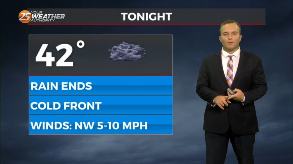
1/18 - Jeff's "Cold Front" Thursday Night Forecast
A cold front passes through the area tonight bringing a wind shift and another shot of cold air. North/northwest winds will be around to start your Friday and…
1/18 - Jeff Vorick's "Spotty Light Rain" Thursday Evening Forecast
Spotty rain/drizzle will be possible at times this evening into tonight. Some reduced visibility may be found if mist picks up and the cloud deck falls…
1/11 - Jeff's "Severe Thunderstorms Possible Tomorrow" Thursday Night Forecast
Mild temperatures persist overnight while winds will be picking up and remaining breezy overnight. They will elevate through the overnight hours and a Wind Advisory will…
1/11 - Jeff Vorick's "Severe Weather Potential" Thursday Evening Forecast
Temperatures remain mild this evening and overnight, and cloud cover fills back in after this evening. The main focus turns to the potential for severe thunderstorms…
12/13 - Jeff's "Developing Coastal Low" Wednesday Night Forecast
Winds remaining a factor overnight and increasing cloud cover will help keep temperatures milder with about 5 degree warmer readings to start your Thursday. For tomorrow, expect…
12/13 - Jeff Vorick's "Mild Temperatures" Wednesday Evening Forecast
Breezy conditions will subside somewhat this evening while partly cloudy skies are expected overnight. Temperatures will be milder with generally 40s across South Mississippi. Thin upper-level clouds…
12/12 - Jeff's "Gradual Changes This Week" Tuesday Night Forecast
It will be cold again overnight but frost concerns should be very isolated. Your Wednesday will feature upper-level clouds streaming in leading to a few clouds…
12/12 - Jeff Vorick's "Cool & Quiet" Tuesday Evening Forecast
Temperatures will be cool this evening but winds will back off gradually. Skies will be mostly clear which will help it turn cold in a hurry…
12/8 - Jeff's "Cold Front/Thunderstorms" Weekend Forecast
Some breaks in the clouds this evening will fill back in as plenty of moisture works into the region. Temperatures remain mild and it will be more muggy as…
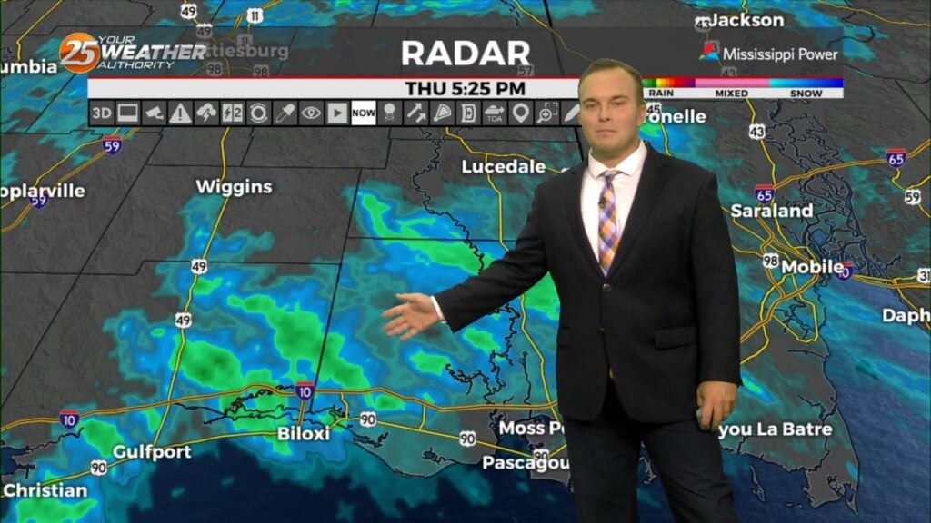
12/8 - Jeff's "Some Stray Rain" Friday Afternoon Forecast
Expect cloud cover to continue this afternoon with an area of disturbed weather nearby. This could also provide for a 20% or so chance of brief light…
11/15 - Jeff's "Gloomy Pattern Continues" Wednesday Afternoon Forecast
Any rain this afternoon will be light in nature with drizzle and intermittent bouts of showers fading by the evening. Winds remain elevated as an area of…
11/13 - Jeff's "Unsettled" Monday Afternoon Forecast
Coverage of rainfall will pick up this afternoon through the evening. Rainfall will be fairly light and steady through about the next 18 hours or so. Tomorrow will be…
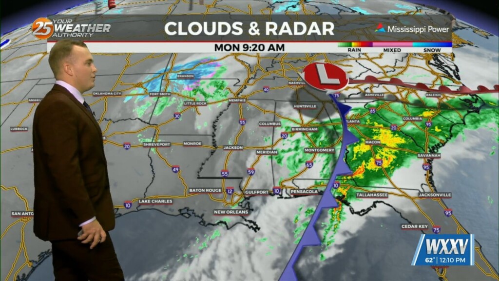
11/13 - Jeff Vorick's "Rain Moves Back In" Monday Morning Forecast
After a relatively dry weekend, rain from a new area of low pressure located off of the Texas coast will move in. By the middle…
10/30 - Jeff's "Colder & Windy" Monday Night Forecast
It will be chilly and windy overnight as a cold front is well past our area. Some light rain will work into South Mississippi towards daybreak and…