Ryan’s Wednesday Night Forecast
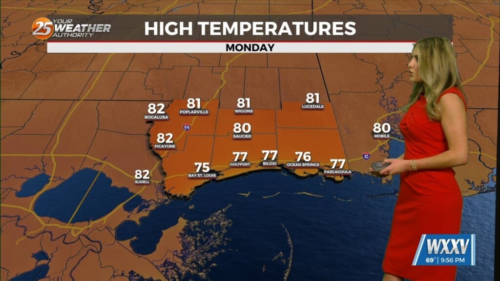
Expect a warm one out there tonight Gulf Coast, the Wednesday night forecast isn’t drastically different from the earlier one, but there are some important changes. Most notably, the “area of interest” NE of Cuba is becoming much more likely to produce a tropical system. Right now, there is a 30% chance of development within 48 hours, and 60% within the next 5 days. Models right now have it moving WNW towards FL, GA, SC or heading up the East Coast and out into the Atlantic, but we’ll have to wait a bit longer for details. Locally, we’ll see a low near 73 with increasing clouds tonight, with a high near 84 under mostly sunny skies tomorrow. Southeasterly winds remain steady and bring more moisture in off the Gulf. Cloud cover will continue to increase as we approach the holiday weekend, but I’m expecting very little in the way of steady showers or thunderstorms at this time. Overall, Memorial Day weekend will be hot, humid, cloudy, and we’ll see at least a few light showers that don’t do much more than increase the humidity for a while. Once we head into next week though, temperatures will leave the 80s and move into the 90s, reminding us that the official start of Summer isn’t far away. Please enjoy your Memorial Day weekend safely, and a very special thanks to the members of the Armed Forces who made the ultimate sacrifice.


Leave a Reply