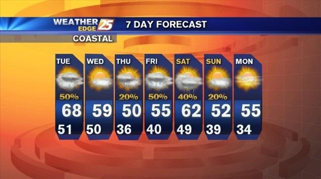
Rain to begin the week, followed by cooler temperatures
Scattered rain possible for Tuesday and Wednesday, then morning temperatures fall below freezing for the end of the workweek.

Scattered rain possible for Tuesday and Wednesday, then morning temperatures fall below freezing for the end of the workweek.
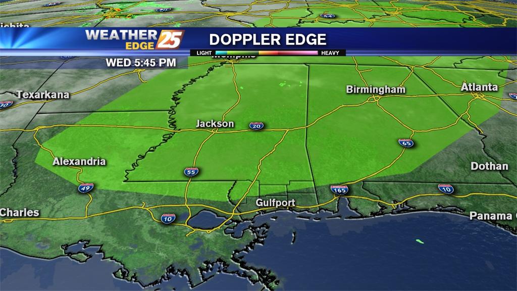
A Tornado Watch is in effect for our area until 3 a.m. Wednesday. Strong to severe storms will be possible in front of and along an approaching cold front.
There is a slight risk for severe weather for the northern portion of our viewing area Thursday. Strong to severe storms will be possible along the approaching cold front with damaging winds the main threat.

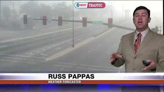
A Dense Fog Advisory is in effect for our coastal counties through 10 a.m. Wednesday.

Partly cloudy overnight with areas of patchy fog, southeast winds at 5 to 10 mph and lows in the mid-50s.

Isolated rain will be possible tonight under cloudy skies with lows in the lower to middle 40s. Mostly sunny tomorrow with highs near 60.

Mostly clear tonight with lows in the mid-30s. Winds will be from the west at 10 mph.

Mostly cloudy tonight with lows in the lower to middle 30s. Mostly sunny tomorrow with highs in the mid-50s.

Rain likely tonight with as much as one to two inches possible and lows in the lower 40s.

Cloudy with rain likely tonight and lows in the upper 30s to lower 40s inland and lower to middle 40s along the coast.
Scattered showers tonight with lows in the middle to upper 30s inland and upper 30s to lower 40s along the coast.

Mostly cloudy tonight with lows falling into the upper 20s to lower 30s inland and lower to middle 30s along the coast.

Partly cloudy and breezy tonight with lows in the lower to middle 30s.

A Dense Fog Advisory is in effect until midnight for coastal counties. Expect areas of dense fog, scattered showers and storms and lows in the middle to upper 40s.
Cloudy with a slight chance for isolated rain and lows in the upper 40s to lower 50s. Areas of patchy fog will be possible overnight into Tuesday morning.

Expect mostly clear skies tonight with lows in the middle to upper 30s. Areas of patchy fog will be possible.

Meteorologist

A wintry mix possible for the beginning of the night, then cloudy with lows in the upper 20s.

A Hard Freeze Warning is in effect until 11 a.m. Friday. Expect freezing temperatures for a 12 to 15 hour period and conditions to reach hard freeze criteria for 5 to 8 hours.

State Auditor's Office and Biloxi Police Department announce arrest in embezzlement investigation.

The main focus of his State of the State Address was education, specifically the new common core standards.

Mississippi Gulf Coast Community College’s Perk Players were awarded the Mississippi Theatre Association (MTA) 2014 Theatre for Youth Festival Overall Production for their performance of “The Amazing Imagination Machine.”
Sub freezing temperatures are to be expected along with breezy conditions and subsequent wind chills that will keep things blustery and frigid.

Clear skies overnight with lows in the upper 20s to lower 30s. Partly to mostly cloudy tomorrow with highs in the mid-50s.

The reward is for any information that will lead to the arrest and conviction of a person or persons responsible for committing two gun shop robberies.

The architect and project manager (team owners shown here) who have been working on the proposed downtown baseball stadium updated City Councilmembers on the status of the project this morning.
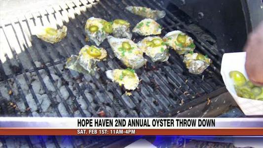
Hope Haven will have it's 2nd annual "oyster throw-down".

2014 4 Man Golf Scramble

Two oyster reef areas opened at legal sunrise today, Jan. 22, officials with the Mississippi Department of Marine Resources (MDMR) said.

The resort features a 14-story hotel newly renovated rooms, three restaurants, a golf course and more.
A reinforcing shot of winter is moving toward South Mississippi and this should keep your heavy coats, hats and gloves at the ready.

A Hard Freeze Warning is in effect from midnight until 8 a.m. Wednesday for Pearl River, Hancock, Harrison and Jackson counties. Expect lows to fall into the lower to middle 20s with wind chill temperatures into the teens for some locations.

Krewe of C.A.S.A. Gala Kicks off the Carnival Season.

Mississippi bill proposes ban on human cloning.

Senators Cochran and Wicker back easing concealed gun limits
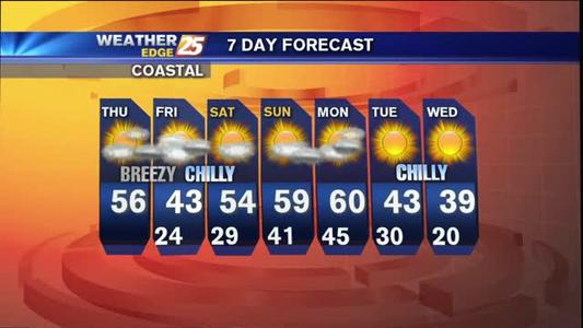
Active weather pattern will bring strong wind speeds and freezing temperatures to South Mississippi twice this week.
Mostly cloudy tonight with lows in the middle to upper 40s. A few areas of isolated showers/drizzle will be possible.

The worldwide anti-bullying campaign taught kindness at Harper McCaughan Elementary.
The winter window will be open for chilly temperatures, strong wind speeds and even a few opportunities for rain showers this week.
Clear skies overnight with lows in the middle to upper 20s inland and upper 20s to lower 30s along the coast.
Clear skies overnight with lows falling into the upper 30s to lower 40s along the coast and middle to upper 30s inland.
Clear skies overnight with light north winds. Lows will be in the lower to mid-20s inland and upper 20s to lower 30s along the coast.
Clouds increase overnight with lows in the middle to upper 30s.
A slight chance for rain overnight with clouds decreasing by Tuesday.
Areas of patchy fog and mist overnight with scattered showers and storms. Lows will be in the upper 50s.
Clouds increasing overnight with skies becoming cloudy. Lows will be in the middle to upper 40s with east winds at 5 to 10 mph.
Mostly clear overnight with lows in the upper 20s inland and lower to middle 30s along the coast.
A Hard Freeze Warning is in effect until 9 a.m. Wednesday. Freezing temperatures will be possible for a period as long as 14 to 16 hours.
A Wind Chill Advisory is in effect until 9 a.m. Tuesday with wind chill temperatures expected to be in the lower teens for an 8 to 12 hour period. A Hard Freeze Warning is in effect until Tuesday a.m. with freezing temperatures expected for a 15 to 20 hour period.

Overnight lows drop into the middle to upper 20s, but north winds at 15 to 20 mph will put wind chill temperatures in the middle to upper teens.