4/28 – The Chief’s “Very Nice Day” Friday Morning Forecast
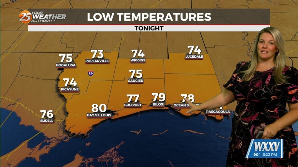
Yesterday’s frontal system will continue sliding east out of the area. Zonal flow will dominate the upper level pattern, with a northerly surface winds becoming SE late morning bringing a warmer air mass. Winds will start to shift southerly in direction late The humid flow will return tonight through Saturday morning, which will help begin to reintroduce moisture and warmer air back into the environment.
Saturday through mid-week… Saturday into Sunday, a disturbance is expected to move through the area, enhancing rain chances again. Easterly surface winds will help to advect warm air and moisture into the area. Some weak upper level divergence will help to enhance lifting and buoyancy in the environment Saturday morning ahead of the system. Numerous showers and storms will be likely Saturday into Sunday, especially during the afternoon hours. Shear is fairly low at the moment, looking at the models, so there could be a strong to severe storm. Moisture availability is favorable and there is plenty of instability. But due to the shear limitations, we are not expecting anything widespread at the moment in terms of severe weather. Some localized flash flooding will be possible Saturday inside of stronger thunderstorms, especially if there are any training storms.
Lovely conditions expect Sunday as weak high pressure ill move back in. Monday into Tuesday, high pressure will build into the area. Northerly surface winds Monday will help to advect stable and cooler, drier air back into the forecast.