3/19 - The Chief's "Very...VERY Nice Afternoon" Tuesday Afternoon Forecast
Surface high pressure in the region will lend to a cool but pretty spectacular day. Moving into the overnight period, surface high will be right along…
Surface high pressure in the region will lend to a cool but pretty spectacular day. Moving into the overnight period, surface high will be right along…

The upper level disturbance that brought the most recent cold front through the region is now east of the Appalachian Mountains and headed to the Atlantic…
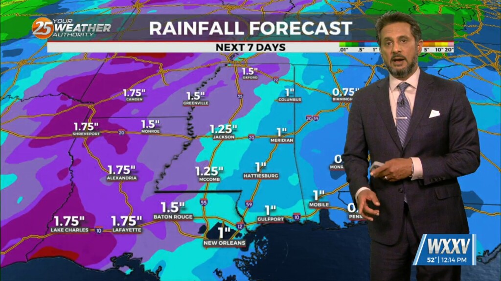
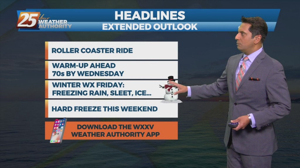
The forecast through the remainder of the workweek is pleasant with no major impacts. Rain should at least hold off till late Friday if not…
Winds will start to come around to southerly today for most of the area. This will help transport some moisture to the area but not enough for…
A large upper disturbance over the eastern states will continue to move off into the western Atlantic on later today. High pressure albeit fairly weak…will…
A relatively benign pattern will continue today before a weak cold front moves through the area. This frontal passage is expected to be dry due to…
This afternoon will bring warmer temperatures but only by a few degrees. Aloft, the upper levels will begin to shift to a more zonal pattern through the day…
Today looks a little warmer than yesterday, but only by a few degrees. Aloft, the upper levels will begin to shift to a more…
An upper level impulse continues to move downstream this morning after producing some light shower activity overnight. Today will be a transitional day for the region…
Surface high pressure will build into the region behind this front today bringing mostly sunny skies and calm winds. Heading into the late evening and…
The word for the next couple of days is moderation. As the high pressure shifts off to the east today, winds will come around to the…
A mid latitude disturbance will be tracking east across the Central and High Plains Friday, crossing the upper/mid-Mississippi River Valley Friday night. As surface ridge north of the…

The next in a series of upper disturbances extended from the Canadian Prairie Provinces to near Salt Lake City to Baja California. This is beginning to turn…
Main concern will be temperatures. Mid and high cloud cover should hang around a good bit of the day, but do expect to see some sunshine late…
A weak cold front diving southward through the mid-west and lower Tennessee valley will move across the area during the day on Friday, with the upper…
A Canadian disturbance will move into the Great Plains and middle Mississippi River Valley tomorrow morning, reaching the Atlantic Coast by sunrise Saturday. Onshore flow never gets…
Clear & cold overnight with an abundance of sunshine tomorrow will allow temperatures to moderate fairly quickly...into the low 60s. As winds turn onshore by Tuesday afternoon, we'll…
The first 36 hours of the forecast is pretty straight forward as high-pressure moves eastward across the area, with onshore flow returning Tuesday. Abundant sunshine will…
Today will be a quiet weather day locally while high-pressure to the west shapes the forecast. Any significant moisture return isn't likely to occur until sometime…
As the warmer air begins to move into the area, fog will be a concern over the next few successive nights as conditions begin to strongly support…
The pattern will put the area in a region dominated by high-pressure. So a quiet weather pattern with slowly moderating temps expected through midweek. Guidance is generally in good…
Clear skies and high-pressure to the north will shape the forecast though Wednesday evening. Colder and drier air mass will begin to modify later today with the…
Clear skies and high-pressure to the north will shape the forecast though Wednesday evening. Colder and drier air mass will begin to modify later today with the high-pressure…
Breezy conditions behind last night's cold front will gradually diminish later in the evening. Low temperatures tonight into Saturday morning will be the coolest of the short term,…