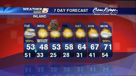
Rain continues Tuesday, with cold air following
A coastal flood advisory is in effect until 5 a.m. Tuesday for Harrison, Hancock, and Jackson counties. Expect tides to be as much as two to three feet above normal.

A coastal flood advisory is in effect until 5 a.m. Tuesday for Harrison, Hancock, and Jackson counties. Expect tides to be as much as two to three feet above normal.
Cloudy skies overnight, with areas of fog, and scattered showers possible. Overnight temperatures will remain mild, only in the upper 50s to lower 60s.
Mostly cloudy skies, a slight chance for isolated showers, and areas of patchy fog possible overnight.

Clouds build overnight, with lows dropping into the lower to middle 50s.

Secretary of State Delbert Hosemann met with the Department of Marine Resources to present this year's Tidelands check toward their goal of preserving coastal resources.

Partly cloudy overnight, with temperatures dropping into middle to upper 40s.

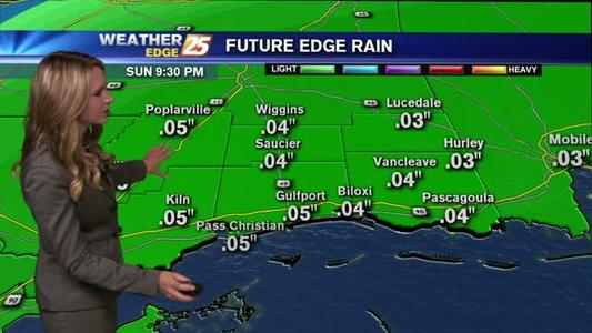
Clouds linger overnight, with isolated showers possible.
Overnight lows only fall into the lower to middle 50s overnight, with isolated showers returning overnight and into Friday.
A freeze warning is in effect until 9 a.m. Thursday. Expect temperatures for some locations to drop near or below freezing as early as midnight, with some areas maintaining freezing temperatures for as much as 9 hours.

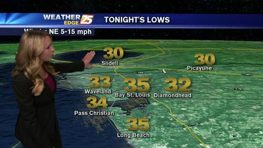
A freeze warning is in effect for our viewing area from 3 a.m. to 9 a.m. Wednesday morning. Expect lows to drop into the upper 20s to lower 30s inland and into the lower to middle 30s along the coast. Wind chill temperatures will be in the lower 20s inland (with a few spots in the upper teens) and middle to upper 20s along the coast.