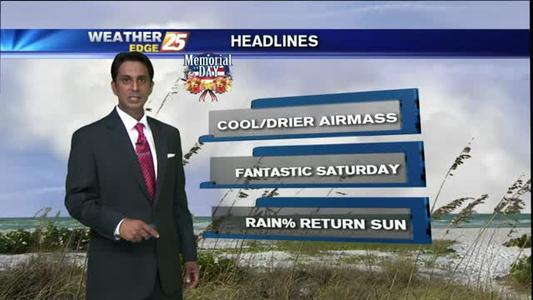
5/25 - Rob's Memorial Day Forecast
A rainy start with t-storms moving across south Mississippi...

A rainy start with t-storms moving across south Mississippi...
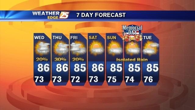
Mixed weather this weekend

Beautiful weekend ahead
A cool and cloudy start will lead to warm conditions and clearing skies...
Nice weekend ahead
Steady conditions last through the weekend

A damp and Humid start with changes on the way...
A chance for scattered showers and storms early tonight, then partly cloudy with lows in the lower to middle 70s.
Light morning fog with a warm & humid day on-tap...

Mostly sunny skies can be expected tomorrow with a slight chance for a shower or storm and highs in the middle 80s, but feeling like the lower to middle 90s.
Rain continues for the beginning of tonight, followed by mostly cloudy skies with lows in the lower 70s.
A humid start with isolated t-storms developing...

A WARM & HUMID start with showers already developing...
A chance for scattered showers and storms early tonight, then mostly cloudy with lows in the lower to middle 70s.
A cloudy start with increasing rain chances...
Mostly cloudy skies tonight, with a slight chance for isolated rain. Lows tonight will drop into the lower 80s.

A cloudy and humid start with hot conditions ahead...
Areas of patchy fog will be possible tonight into tomorrow, with mostly cloudy skies, and scattered rain possible. Overnight lows will drop near 70.

A humid and cloudy start with t-storms on-tap...
Scattered showers and storms will be possible tonight with lows dropping into the lower 70s. A few storms could be strong to severe, although they are expected to decrease in intensity as we continue through the evening.
A warm & Humid start as a cold front approaches...
Hot and humid weekend.
Great looking weekend
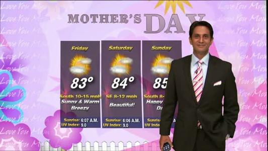
Patchy morning fog will lead to a beautiful day/weekend...