6/13 – Night Rob’s “When’s The Relief” Monday Night Forecast
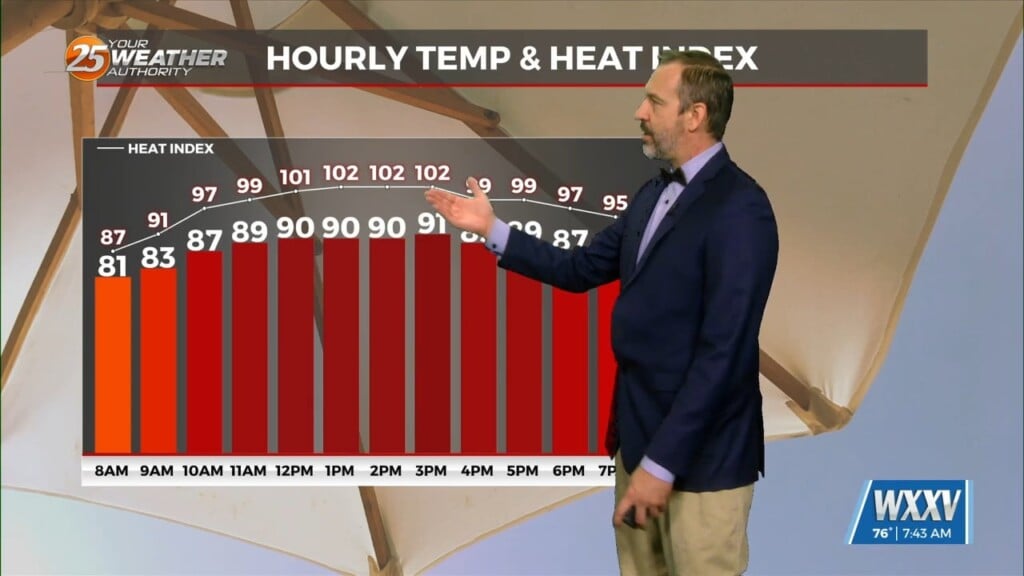
As of Monday night, it’s not looking like our heat advisory will be extended a third day into Tuesday, but it won’t be much different from a real-feel standpoint. Pascagoula (Moss Pt/Trent Lott Airport) had a real-feel temperature of 112 degrees this afternoon, and Gulfport peaked at 106. Hot temperatures and high humidity will be the focus of the forecast through tomorrow. Shower activity was hard to come by today, and that will be the case Tuesday as high pressure (sinking air) counters the rising air needed for thunderstorm development.
PRECAUTIONARY/PREPAREDNESS ACTIONS FOR DEALING WITH HEAT… Drink plenty of fluids, stay in an air-conditioned room, stay out of the sun, and check up on relatives and neighbors. Young children and pets should never be left unattended in vehicles under any circumstances. Take extra precautions if you work or spend time outside.
As for those storm chances, they’ll be very low through Tuesday, then ramp up to about 30% for Wednesday and Thursday. Any activity would remain spotty and fizzle out in the evening hours. We could certainly use some more rain along with some temporary relief from the heat.
The high pressure causing the heat will reassert itself later in the week and heat advisories could be posted again. This secondary heat peak would be Friday and Saturday with highs in the mid 90s. Storm chances dwindle back down to 20% or less from Friday through next weekend.