Wet and unsettled pattern ramps up ahead of Memorial Day Weekend
Meteorologist Sam Lucey has a look at the week ahead
A wet and unsettled weather pattern is setting up across South Mississippi and the Gulf Coast heading into the holiday weekend, with repeated rounds of showers and thunderstorms expected through much of next week.
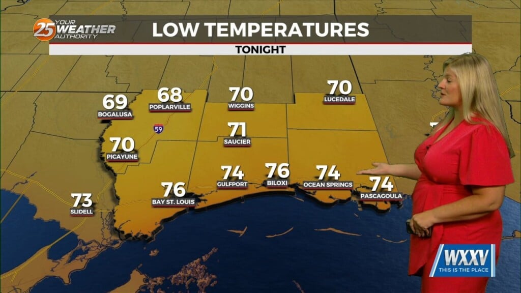
Rain chances begin increasing tonight as scattered showers and thunderstorms become more widespread overnight. Some locally heavy rainfall will be possible at times, with overnight lows staying warm and muggy in the mid 70s.
Friday will bring another round of showers and thunderstorms, especially during the morning and afternoon hours. Despite the rain, temperatures will still climb into the lower 80s thanks to the humid air mass in place across the region.
The unsettled pattern continues through the weekend, including Saturday and Sunday, with scattered to numerous showers and storms developing each day. While there will still be dry periods mixed in, outdoor plans may need flexibility as storms could develop at almost any point, especially during the afternoon and evening hours. High temperatures will generally remain in the low to mid 80s with overnight lows in the mid 70s.
Memorial Day itself is also looking soggy at times, with more off-and-on showers and thunderstorms expected throughout the day. The active pattern does not appear to move out quickly, as daily rain and storm chances are expected to continue into the middle of next week.
At this time, widespread severe weather is not expected, but heavy downpours, lightning, and brief gusty winds will remain possible in stronger storms. With several consecutive days of rain in the forecast, localized ponding on roads and poor drainage could also become concerns in areas that see repeated heavy rainfall.