7/15 – Sam’s “Warm and Humid” Tuesday Evening Forecast
It was another hot one across South Mississippi today with highs near 95° and a heat index pushing up to 108°. Tonight stays mostly clear and warm, with lows in the upper 70s.
By Wednesday we are still expecting another hot day to start out, with a heat advisory in effect until 7pm. By the afternoon, tropical moisture moves in, fueling a higher chance for storms—especially late in the day. Storms that do develop could bring heavy downpours at times, and rain chances stay elevated through Wednesday night. 
That tropical influence continues Thursday and Friday as an area of low-pressure tracks into the northeastern Gulf. There’s a chance it could develop into a tropical depression, but even without development, it’s expected to bring widespread rain, thunderstorms, and the potential for localized flash flooding across the region.
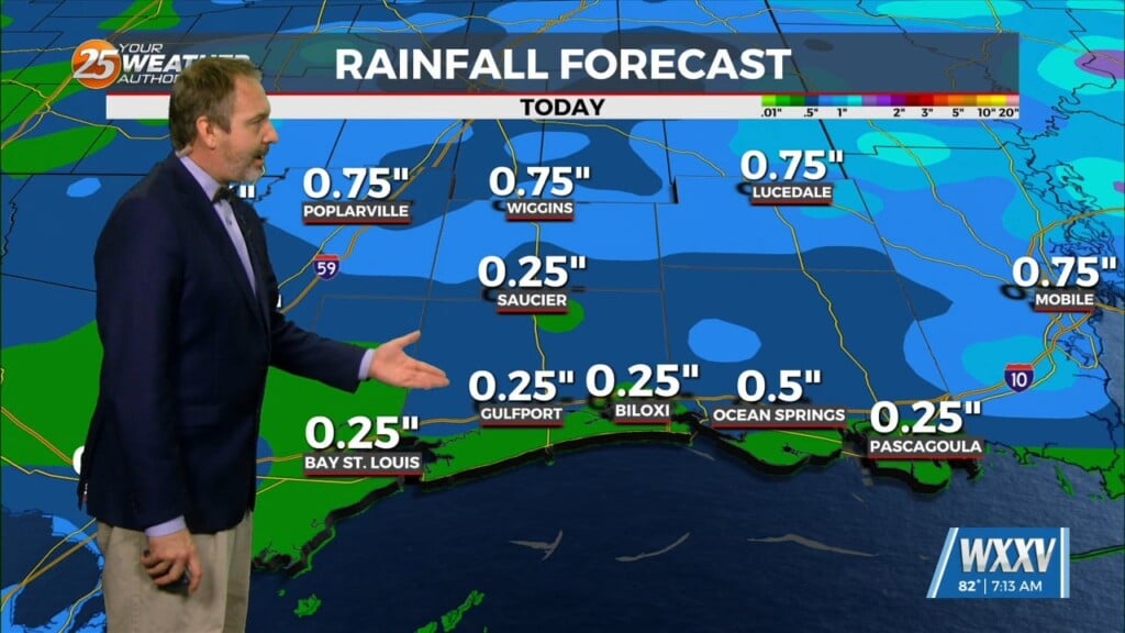
Highs drop into the upper 80s for Thursday and Friday bringing a slight relief from the heat, but heavy rain will be our biggest concern both days as we expect much of the area to see 2-3 inches of rain and coastal areas up to 5 inches.
Satellite and radar data show the system slowly organizing, and once in the Gulf, conditions become a little more favorable for development. There’s a 40% chance of tropical formation over the next couple of days, with the disturbance expected to approach the Louisiana coast on Thursday.