5/22 – The Chief’s “Mercury Rising” Wednesday Morning Forecast
The fight between a series of fast moving disturbances sliding along the I-20 and further north and high pressure to the E/SE will be the main forecast challenge through Friday night. Although the fast moving and weak disturbances will help to weaken the high pressure slightly, the amount of dry air and subsidence in place will keep a great deal of convective inhibition in place across nearly all of the forecast area through the period.
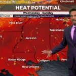
The main impact from this strong high pressure will be continued warm temperatures in the upper 80s and lower 90s each afternoon. Lows will dip into the upper 60s and lower 70s each night. As temperatures cool each night, boundary layer conditions will support the development of a scattered to broken low stratus deck each night shortly before daybreak, especially over more inland areas. Overall, the continuation of a very benign weather regime is expected through Friday night.
Starting off Memorial Day Weekend on Saturday continued hot and dry through Sunday. The next focus will be rain chances Monday, as we’ve been advertising the chance for an isolated shower or two. Regardless of ample surface warming/mixing, should struggle to attain distinct shower chances especially given lack of large-scale dynamic lift. Beyond however going into Tuesday, rain chances will likely bump up more as a front approaches the area, providing more lift and eroding the in place inversion to support scattered showers. Thankfully, this will likely back the heat down some underneath mostly cloudy skies.


