
06/27 Ryan's "Rain Returns" Friday Morning Forecast
The middle of the week was noticeably less active than many recent days in regards to afternoon showers, but now the rain returns as we head into the…
The middle of the week was noticeably less active than many recent days in regards to afternoon showers, but now the rain returns as we head into the…
Saw a little rain this afternoon and we can se the chance aging tomorrow for more small pop ups. A few showers cooling places down but…
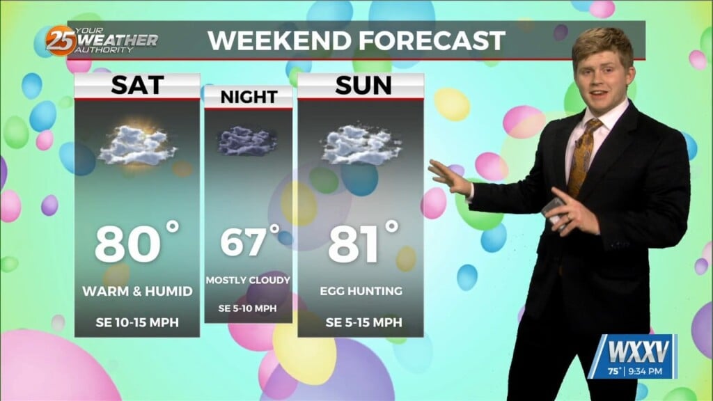
Easter weekend is going to be warm with rain chances next week. Saturdays daytime highs in the 80s and mostly cloudy. Sunday to remain…
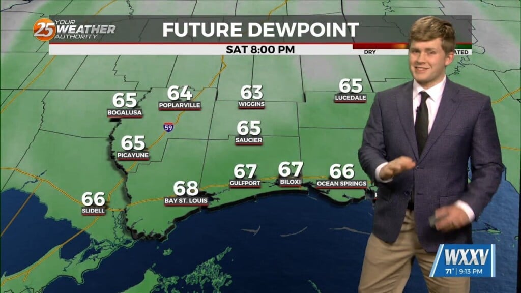
A warm and humid couple of days ahead before Easter. Temperatures will continue to rise in the upper 70s and low 80s along with more…
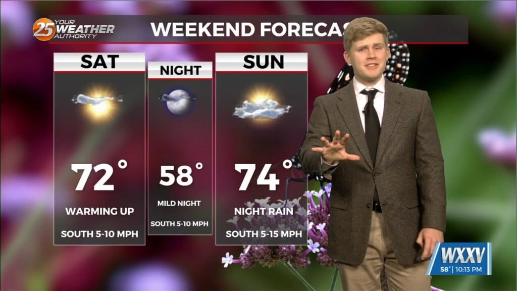
Definitely a spring like weekend on tap but leads to Monday storms next week. Saturday morning will be clear with lows in the mid 40s to…
Chilly Friday morning but a much warmer weekend on the horizon. A cold start to Friday Morning with a few frost advisories in Stone…
On and off rain showers for most of the day on Saturday but next week seeing a warmer pattern. There is a marginal level 1 of…
A great weekend to enjoy parades but storm chances increase next week. The weather will be quite pleasant this weekend if you plan on heading…
Great weather through the weekend but tracking storms early next week. A warm day earlier but affected by a weak cold front which will cool…
Weakening hurricane Helene racing north-northeast through Georgia. The low pressure centered near Memphis helping to accelerate Helene northward. Both are helping to pump cooler and drier…
Forecast will remain fairly quiet today and through the weekend but there is still a small chance we could see a shower or two this weekend. Northwest flow…
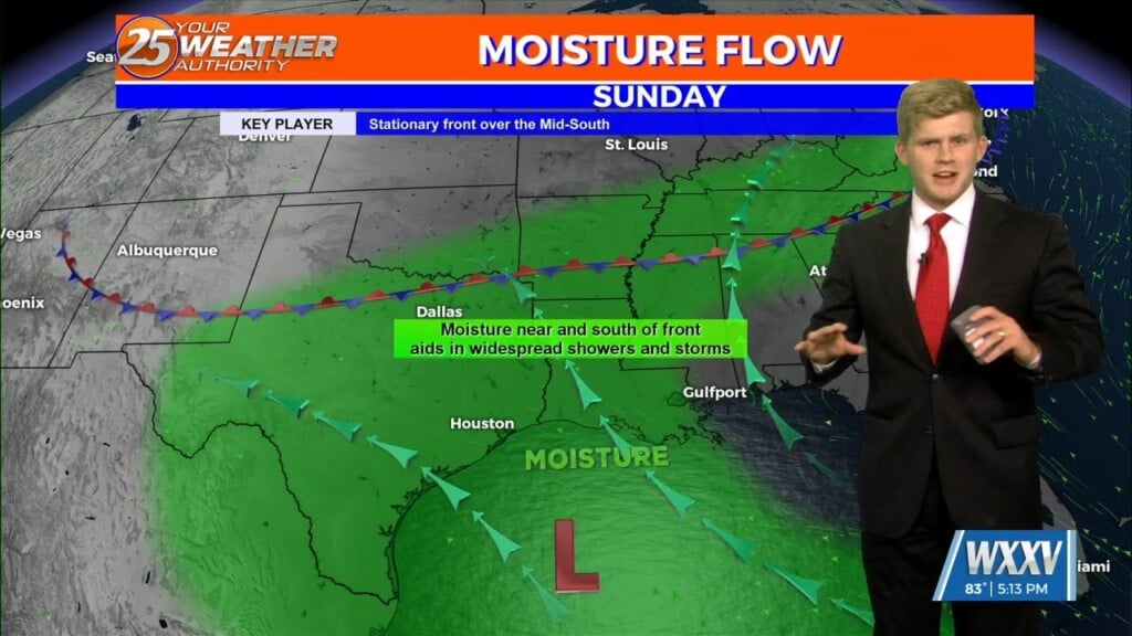
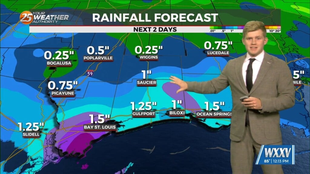
Low level flow will continue to pump tropical moisture into the local area, resulting in widespread showers and storms. Have extended the flood watch through…
Storm energy is going faster today as the area was quickly destabilizing and a better southeast to south- southeast push in the lower levels. This is allowing…
Tomorrow and Sunday will continue to be HOT with isolated to scattered showers expected. These showers and storms will be mostly in the afternoon/early evening…
We have had active southwesterly flow aloft and today it was an entertaining and loud afternoon. Numerous showers and thunderstorms have developed and several locations have gotten…
Overall, entire weather pattern is benign with the high pressure bringing moderate temperatures and no precipitation. Northwest flow aloft will give us one more night of cool…
Rain will fill back in this afternoon and especially into this evening. Expect heavy rain at times as a cold front makes its way through…
The upper level pattern is transitioning just slightly with a weak disturbance moving into the central Gulf States today. The best uptick in cloud…
It will be mild and pleasant to start Saturday. Temperatures will quickly warm with plenty of sunshine early on. Clouds begin to move in by the afternoon but temperatures…
Skies remain clear this evening and warm temperatures will gradually cool off. A cold front in the area will finally slide through South Mississippi overnight. It will provide…

The forecast is pretty simple for the next 7 days. Currently there is a stationary boundary well to the south of our area in the gulf. High pressure is…
A stalled stationary front in the northern Gulf of Mexico, continues to flare up showers well to the south. High pressure to the northwest will be the dominate feature…
A stalled stationary front in the northern Gulf of Mexico, continues to flare up showers well to the south. High pressure to the northwest will be…
This afternoon there is a cold front just to the south of our area along the Mississippi sound. This cold front will not affect temperatures that’s much as…