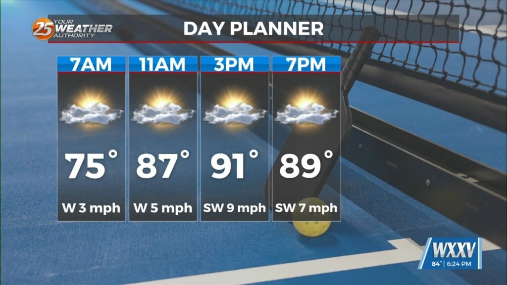
6/20 – Night Rob’s “Summer Arrives With HEAT” Monday Night Forecast
It wasn’t a particularly bad Monday as heat started to build, but some relief arrived from scattered storms and cloud cover by mid-afternoon. Gulfport hit a real-feel of 106 and Pascagoula hit 109 early, and this is just the beginning. Tuesday will not be too different from Monday, but a heat advisory will likely be needed for Wednesday through the rest of the week. A sea breeze will get initiated around noon along the Mississippi coast and this should help get some thunderstorms started will inland this afternoon/evening. A few of these may be able to keep going after dark but for the most part, this activity will dissipate with the exception of marine showers/t-storms. This pattern will repeat a bit on Wednesday before high pressure quells further development later in the week.
A blocking high-pressure will remain through much of the week over the central part of the nation. The center of this high pressure will meander throughout Arkansas, LA and TX through the end of the week. Afterwards, this high will begin to flatten out north to south; this will cause the high to build back toward the southwest U.S. by the end of the week through the weekend. Guidance continues to give this year hottest temps to come Thursday-Saturday as the map may be littered with 100s those afternoons. Rain/storm chances will be low this week, which is a bit problematic as we’re running behind on rainfall again. Next week will bring changes and open the area to a more normal distribution of summer showers/t-storms and somewhat cooler temps over the area.