5/9 – Trey Tonnessen’s “Enhanced Severe Risk” Thursday Night Forecast
Meteorologist Trey Tonnessen
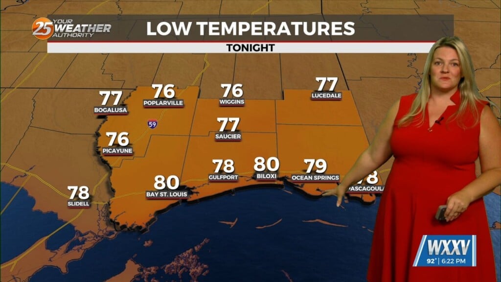
The cold pool in the wake of the convection will allow a front currently draped over north Louisiana to surge southward late tonight into tomorrow morning, and fully expect to see the front clearing the area by late tomorrow morning. Strong dry air and negative vorticity advection will follow the front and the departing upper level vort max tomorrow into tomorrow night, and this will lead to rapidly clearing skies tomorrow afternoon. One hold-up is that colder air is not expected to initially move into the area, and the combination of increasing solar insolation, weak downslope heating on the back of northerly winds, and dry air will allow temperatures to climb into the upper 80s and even lower 90s. The colder air will finally move in by tomorrow night, and temperatures will rapidly fall into the upper 50s and 60s by Saturday morning. Temperatures will be near average for Saturday with highs warming into the low to mid 80s and lows dipping back into the upper 50s and 60s Saturday night.
As always: A cloudy day is no match for a sunny disposition. Be nice to each other.
-Meteorologist Trey Tonnessen