09/14 – Brantly’s Monday Morning Tropical Update
(WXXV) — As of 4 a.m. Monday, Tropical Storm Sally has maximum sustained winds at about 60 miles per hour with higher gusts.
Sally is moving toward the west-northwest near 9 mph. This general motion is expected today, followed by a decrease in forward speed and a turn to the northwest tonight and a northward turn sometime on Tuesday.
Strengthening is expected over the next day or so, and Sally is forecast to become a hurricane by tonight, with additional strengthening possible before the center crosses the northern Gulf Coast.
On the forecast track, the center of Sally will move over the north-central Gulf of Mexico today, and approach southeastern Louisiana this afternoon, and make landfall in the hurricane warning area on Tuesday. Afterward, Sally is expected to move slowly north-northeastward near the northern Gulf Coast through Wednesday.
Tropical-storm-force winds extend outward up to 125 miles from the center.
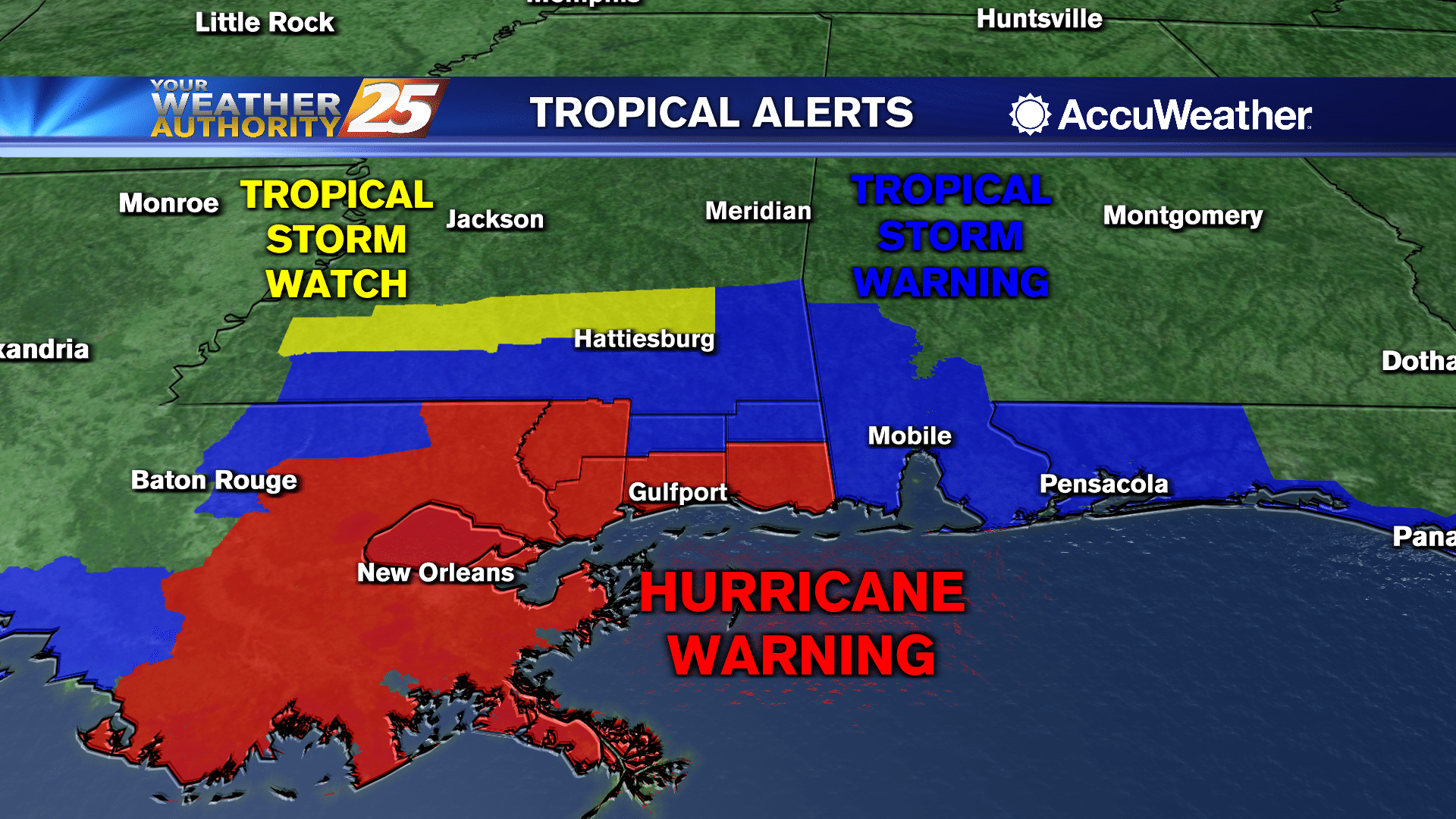
WATCHES AND WARNINGS:
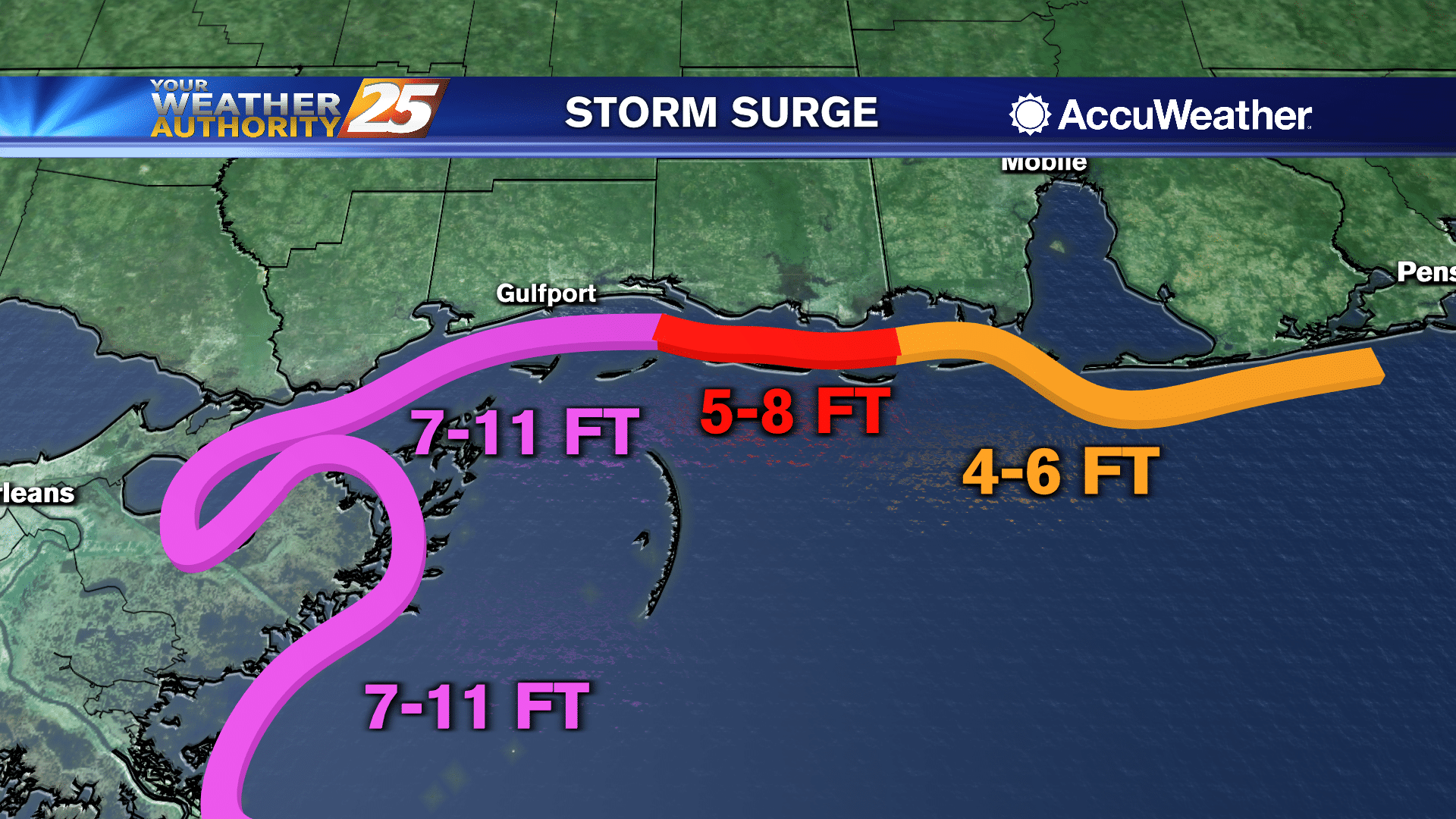
- A Storm Surge Warning is in effect for Port Fourchon, Louisiana to the Alabama/Florida Border, including Lake Pontchartrain, Lake Maurepas, Lake Borgne, and Mobile Bay.
- A Hurricane Warning is in effect for Morgan City, Louisiana to the Mississippi/Alabama Border, including Lake Pontchartrain and Lake Maurepas including metropolitan New Orleans.
- A Tropical Storm Warning is in effect from the Mississippi/Alabama Border to Indian Pass, Florida and from to Intracoastal City, Louisiana to west of Morgan City, Louisiana.
- A Hurricane Watch is in effect from the Mississippi/Alabama Border to the Alabama/Florida Border.
This is a life-threatening situation. Residents located within these areas should take all necessary actions to protect life and property from rising water and the potential for other dangerous conditions. Promptly follow evacuation and other instructions from local officials.
A Hurricane Warning means that hurricane conditions are expected somewhere within the warning area. A warning is typically issued 36 hours before the anticipated first occurrence of tropical-storm-force winds, conditions that make outside preparations difficult or dangerous. Preparations to protect life and property should be rushed to completion.
A Tropical Storm Warning means that tropical storm conditions are expected somewhere within the warning area within 36 hours.
A Hurricane Watch means that hurricane conditions are possible within the watch area.
A Tropical Storm Watch means that tropical storm conditions are possible within the watch area, in this case within 12 to 24 hours.
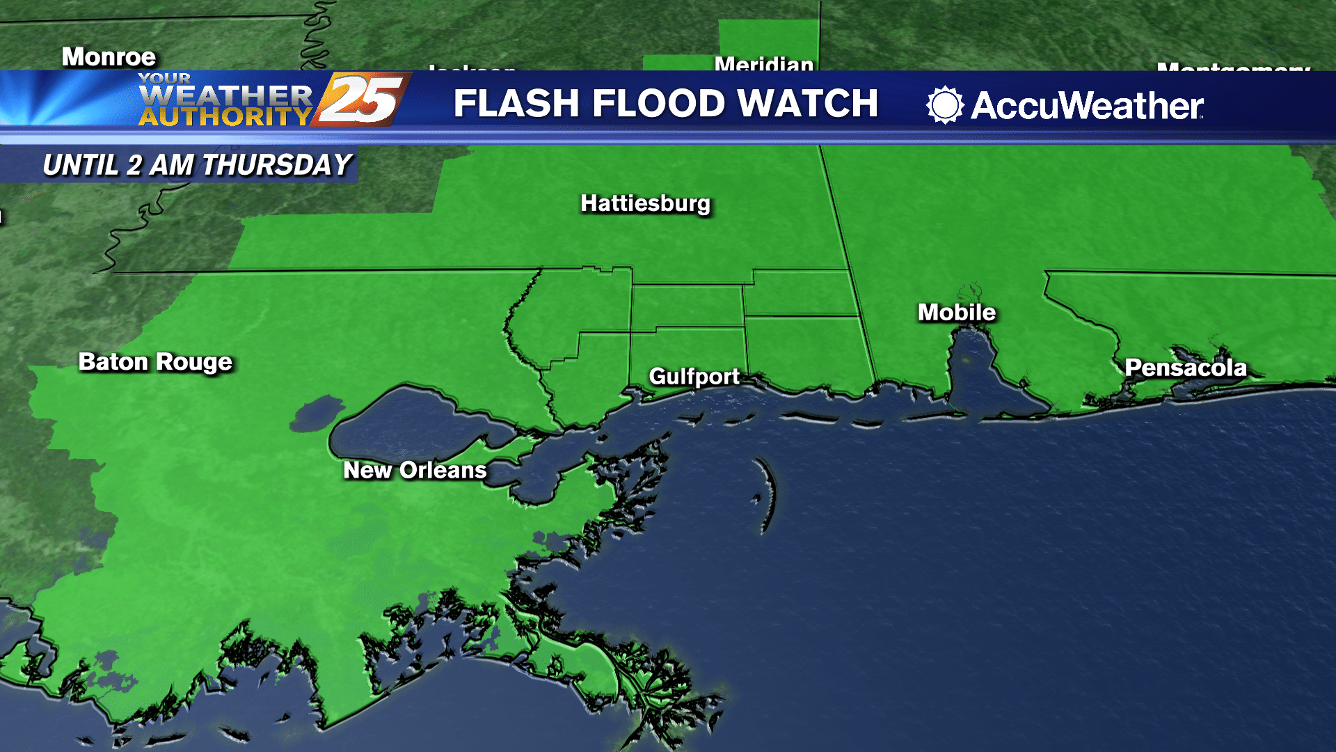
Sally is expected to be a slow moving system resulting in significant flash flooding for the central Gulf Coast Monday into Wednesday.
Sally is expected to produce rainfall of 8 to 16 inches with isolated amounts of 24 inches over portions of the central Gulf Coast from the western Florida Panhandle to southeast Louisiana from Monday through the middle of the week.
This rainfall will likely result in new widespread minor to isolated major flooding on area rivers.
Changes to forecast track and intensity are likely over the next few days. Check back for updates.


Leave a Reply