Tropical Depression Nine forms in the Gulf, expected to strengthen quickly
Meteorologist Sam Lucey has a look at the forecast for south Mississippi

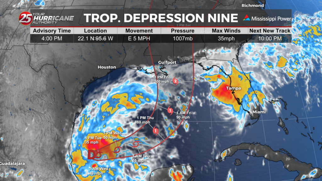
Tropical Depression Nine has formed over the Gulf of America and is expected to strengthen quickly as it moves east, then turns northeast toward the northern Gulf Coast.
As of 4 p.m. Tuesday, the system was about 630 miles southwest of the mouth of the Mississippi River, with maximum sustained winds of 35 mph. It was moving east at about 5 mph.
The depression is expected to become a tropical storm by early Wednesday and a hurricane by Thursday. The forecast track takes the system north of the Yucatan Peninsula Thursday before it turns northeast and approaches the U.S. northern Gulf Coast Friday.
There are currently no coastal watches or warnings in effect, but interests along the northern Gulf Coast should closely monitor the system.
Rain could become the biggest concern
Rainfall will increase across the Gulf Coast as the system approaches. From Friday through the weekend, 3 to 6 inches of rain is forecast across portions of the central Gulf Coast, from southeastern Louisiana to the Florida Panhandle, with localized totals up to 10 inches possible.
That could lead to flash flooding, urban flooding and some river flooding, especially where heavier rain bands persist.
For the Mississippi and Alabama Gulf Coasts, the exact track and strength will determine where the heaviest rain and strongest winds set up. Conditions are expected to become increasingly unsettled late this week, with the greatest impacts possible Friday into the weekend.
We will continue to track the system closely as it strengthens and moves toward the northern Gulf Coast.