11/8 - Jeff's "Changes Ahead" Wednesday Afternoon Forecast
A few clouds to partly cloudy skies can be expected this afternoon with warm temperatures yet again. Winds remain out of the south which will keep humidity around.…
A few clouds to partly cloudy skies can be expected this afternoon with warm temperatures yet again. Winds remain out of the south which will keep humidity around.…
This afternoon will bring warmer temperatures but only by a few degrees. Aloft, the upper levels will begin to shift to a more zonal pattern through the day…
Breezy conditions will continue today and with calmer winds expected tonight, this will help tremendously toward radiational cooling. Temperatures will be…
Strong cold advection and this looks to continue over the next 24 hours or so. This will help force temps to the lowest levels…
A n approaching surface front should clear the land by the afternoon as winds shift out of the north. The upper front will lag behind the…
A disturbance over northern Mexico is promoting its development as it ejects over the southern plains. High pressure over the GOM will keep the disturbance too…
A very weak front just north of the area will continue to move toward the Atlantic Coast today and Saturday with upper high pressure beginning…
At the surface, high pressure currently extends along the Atlantic Coast into the northeast Gulf of Mexico. Low pressure over Wisconsin had a cold front…
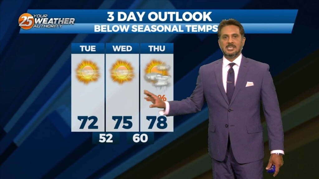
Lovely…but below seasonal temperatures will continue this afternoon as high pressure slides eastward to the Atlantic Coast by Wednesday afternoon, eventually turning low level flow onshore…
High pressure to the NE continues to shape the forecast but as expected, models have backed off of bringing showers into the area from the gulf…

High pressure remains dominate over the area and this will remain the case into mid-week. A few showers could tickle the coast from time…

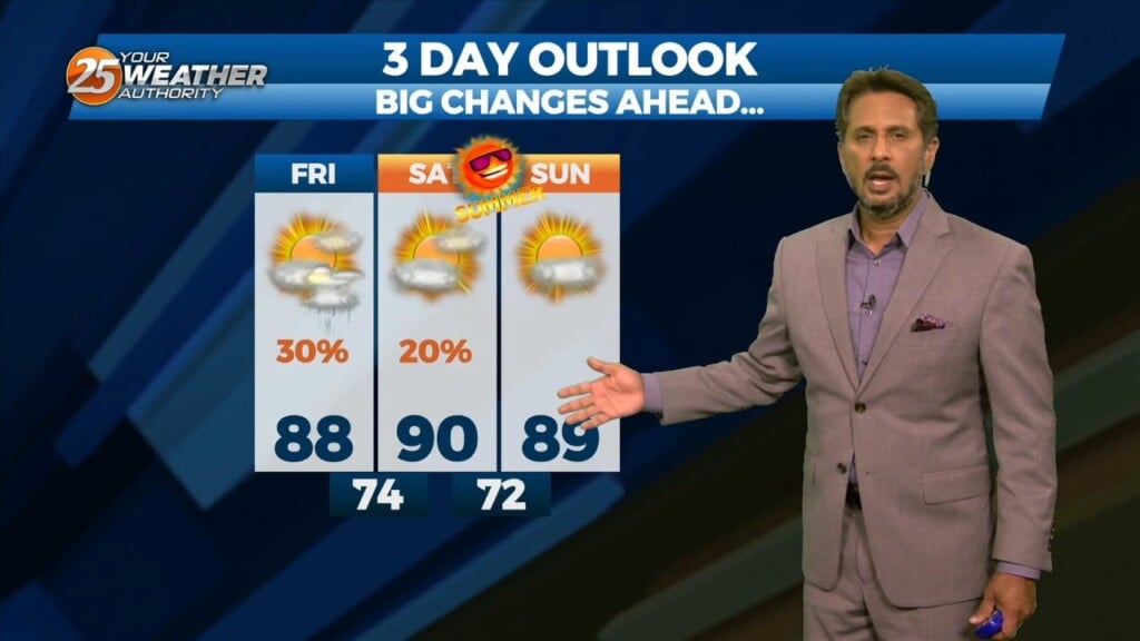
A BEAUTIFUL Friday afternoon ahead with high-pressure to the NW and a weakling stationary front well to the south. Models pinpoint enough moisture above a well-mixed layer…
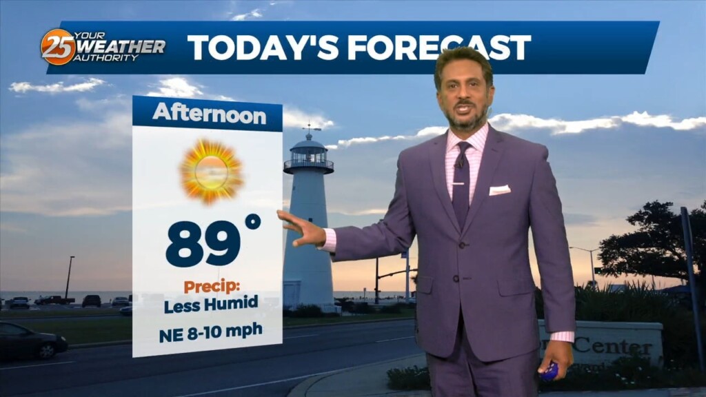
This afternoon will be very similar to yesterday in terms of low humidity values and temperatures warming back into the upper 80s to low 90s. Tuesday…
Scattered showers and thunderstorms will be possible this afternoon as temps warm into the upper 80s/low 90s within a fairly moisture regime. Although the latest…
The month of September will bring a changing pattern where dominant high-pressure in the SE begins to break down allowing cold fronts to move through the…
Multiple weaknesses in the overall pattern including an area of low pressure to the west has brought rain chances back to the region. Strong cored…
Upper level high pressure continues to spread eastward through the central MS River Valley and into the southern Appalachians. Basically, in a nutshell, same old same old…

At the surface, a very subtle weakness resides across portions of the region, however, this feature hasn’t been as productive as I'd like in terms of…
An easterly wave is currently located from Appalachia Bay FL down to the NE’tern Gulf of Mexico. This wave will also get flattened down on its…
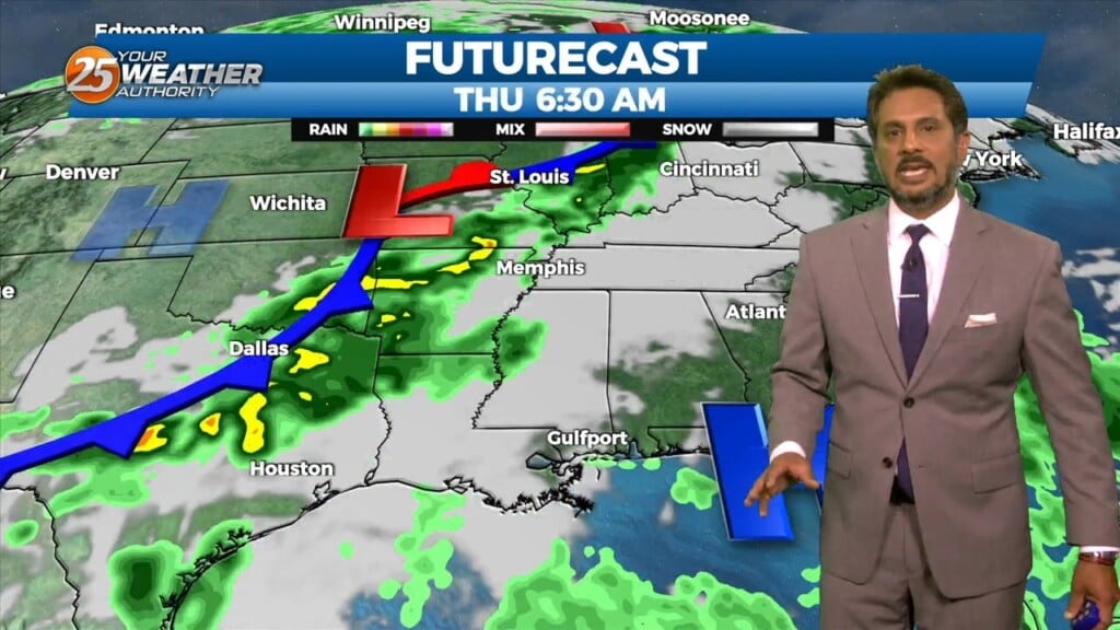
An area of low pressure over-southern Minnesota will move to the Mid-Atlantic states by Tuesday night, dragging the trailing frontal boundary into the local area during…
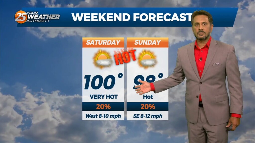
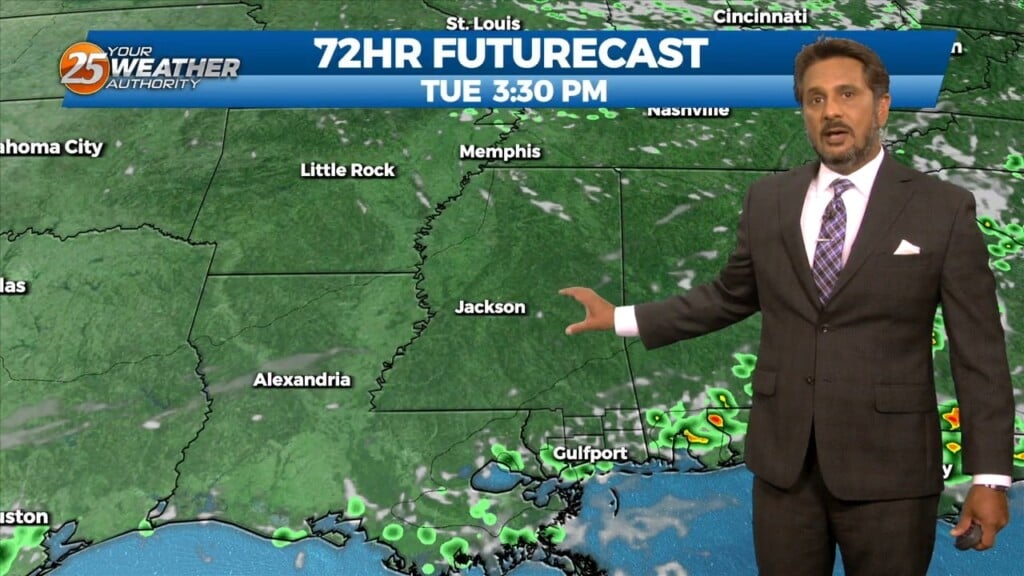
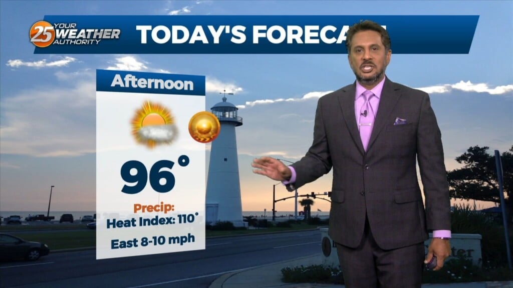
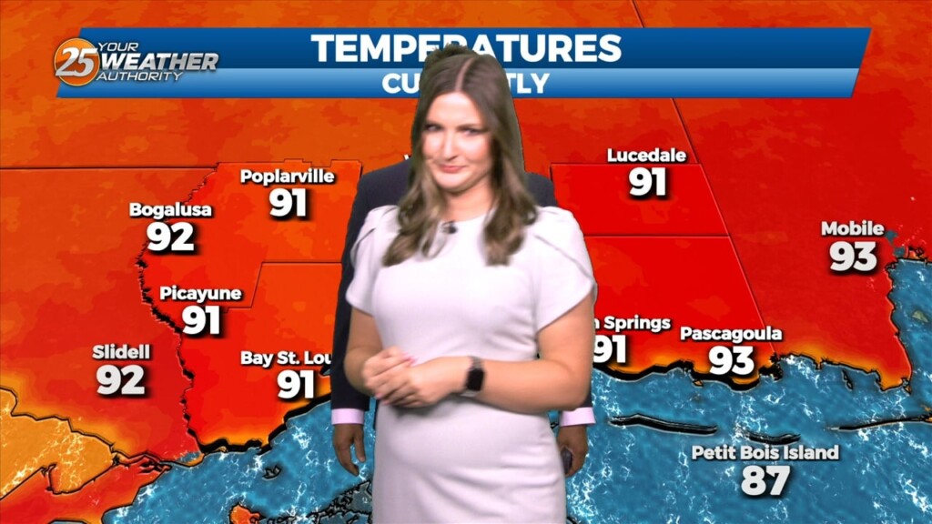
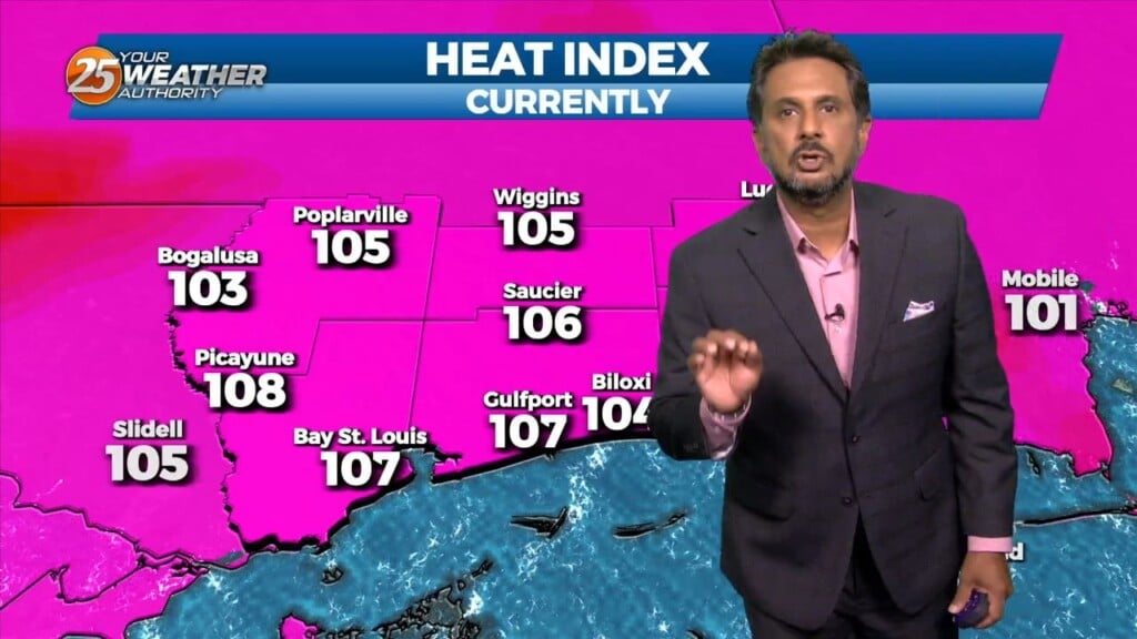
The main focus through this afternoon and the next couple of days will be the continuation of Excessive heat across the southern six counties. AN EXCESSIVE…
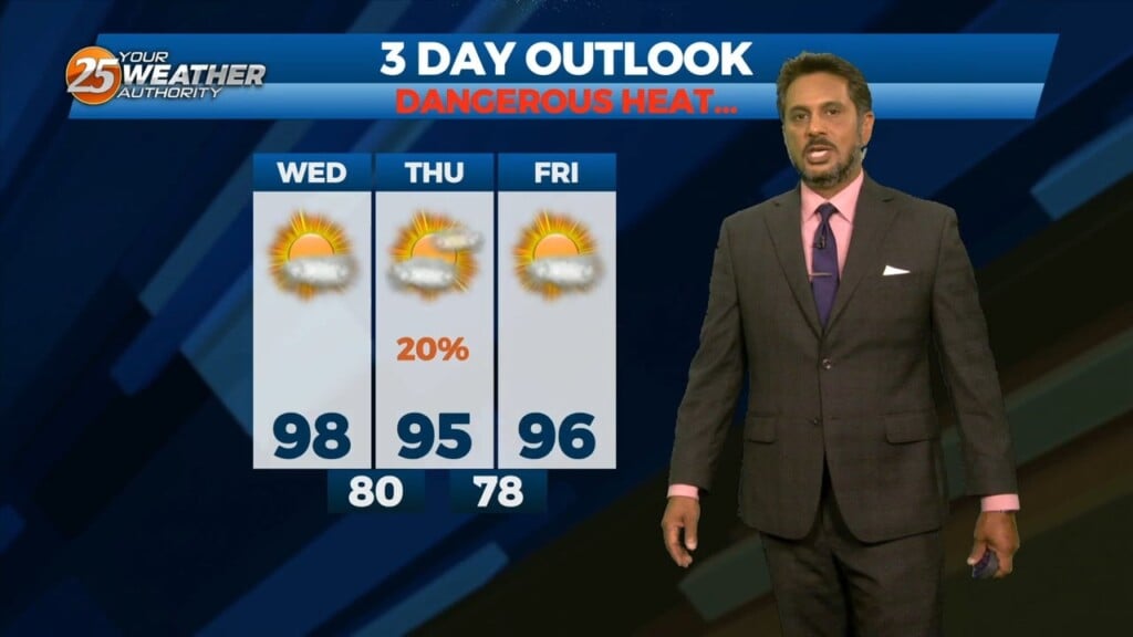
With little in the way of upper level support across the central Gulf States, expect only limited rain chances through mid-week…with another hot afternoon ahead. Models…
Not much in the way of anything to help showers/t-storms get started today and relatively low chances will continue over the next several days. But some…
A HEAT ADVISORY is in effect once again this afternoon with heat indices between 106-112 degrees expected. Synoptically, the region remains under the influence of a large…