2/27 – Trey's “Rainy Outlook” Tuesday Night Forecast
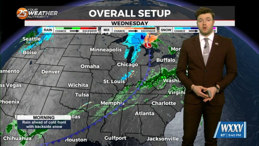
A largely zonal flow pattern will develop over the area on Friday and remain in place through next Monday. Embedded within this zonal flow regime, a series…
A largely zonal flow pattern will develop over the area on Friday and remain in place through next Monday. Embedded within this zonal flow regime, a series…
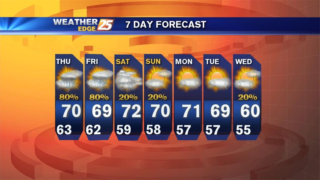
A Flash Flood Watch has been extending until 7 p.m. Friday as more rain is expected. Flood Warnings also continue to be in effect for the Biloxi, Wolf and Tchoutacabouffa rivers. Scattered showers and storms will be possible for the rest of tonight, with lows dropping near 70.
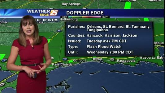
A Flash Flood Watch is in effect until 7 p.m. Wednesday, along with Flood Warnings for the Biloxi River (near Lyman) until Thursday afternoon, the Wolf River (north of Gulfport) until Friday afternoon and the Tchoutacabouffa River until Thursday morning.
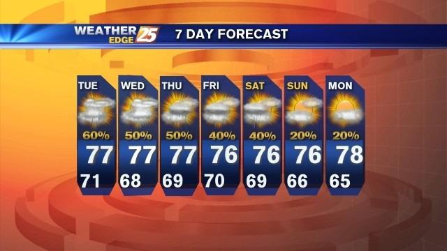
Mostly cloudy skies are expected tonight, with a slight chance for rain and highs near 70.
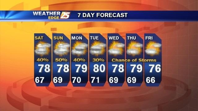
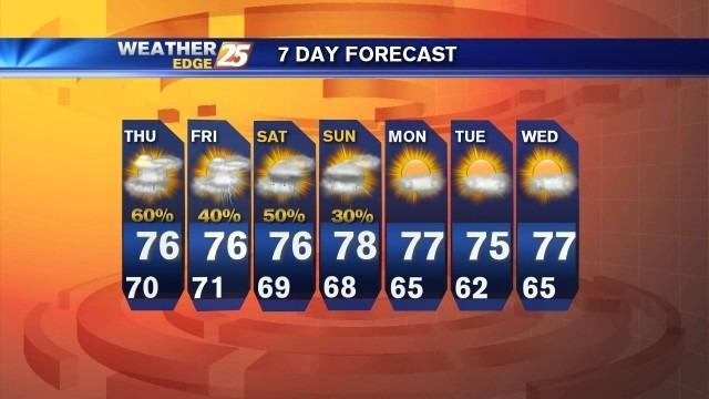
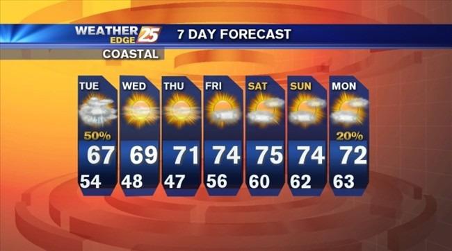
Expect mostly cloudy skies for Saturday with scattered showers and storms, especially near the coast. Highs will warm into the upper 70s, with overnight lows dropping into the upper 60s.
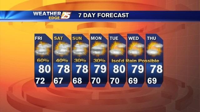
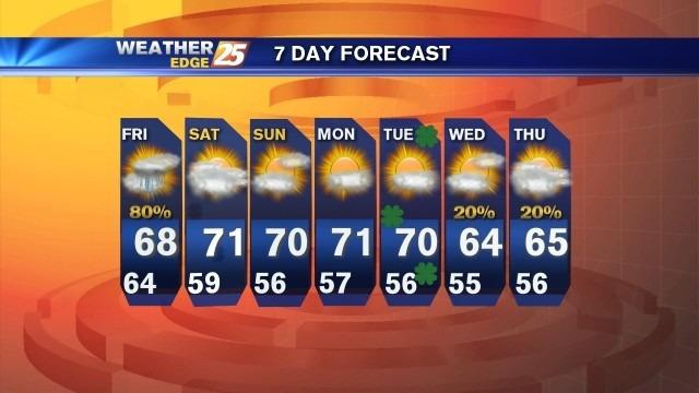
Scattered showers and storms will be likely Friday, along with a slight chance for a few strong to severe storms and heavy rainfall. Temperatures will make it near 80 by the afternoon.
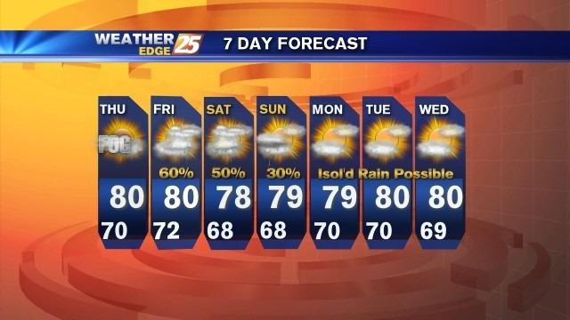
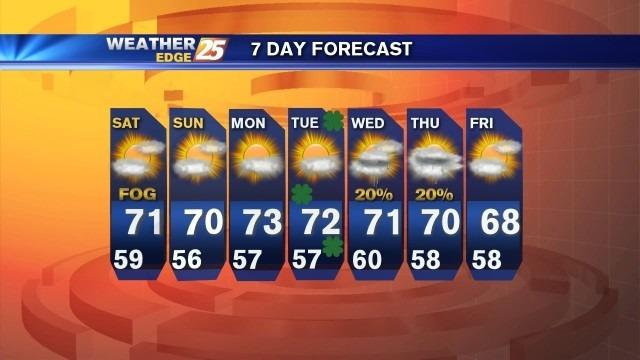
Areas of patchy fog will be possible again for Thursday morning with partly sunny skies and highs near 80.
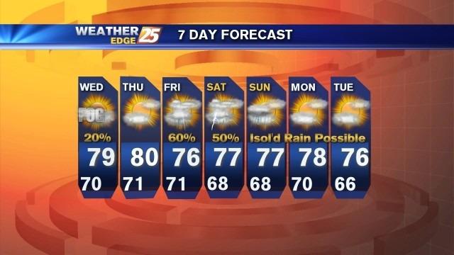
There is a chance for isolated rain overnight under mostly cloudy skies with lows falling near 70. Areas of fog will be possible overnight into early Wednesday morning.
A few showers and storms will be possible during the early part of tonight, followed by mostly cloudy skies with areas of patchy fog. Overnight lows will drop into the upper 60s to lower 70s with southeast winds at 5 to 10 mph.
As a cold front slide through the region tonight, expect a chance for scattered showers and storms. Overnight lows will drop into the lower 60s with south winds at 5 to 15 mph, shifting from the northwest behind the cold front.
Partly sunny skies with a slight chance for isolated rain ahead of the approaching cold front. Highs will be in the upper 70s to lower 80s with south winds at 10 to 20 mph.
Areas of patchy fog can be expected tomorrow morning, then skies will be mostly cloudy with highs in the middle to upper 70s.

Areas of patchy fog will be possible overnight, with lows dropping into the upper 50s to lower 60s.
Expect mostly cloudy skies tonight, with scattered rain and lows near 50. Cloudy skies clear throughout the day tomorrow leaving sunshine, breezy conditions and highs in the upper 60s.
Mostly cloudy overnight with patchy fog possible and lows in the lower to middle 60s.
Expect passing clouds tonight along with areas of patchy fog. Overnight lows will drop into the middle to upper 50s.
Areas of fog can be expected tonight into tomorrow morning under mostly cloudy skies. Lows will dip into the lower 60s.
Mostly cloudy tonight with a chance for scattered rain. Lows will drop into the lower to middle 60s along the coast and upper 50s inland.
Mostly cloudy tonight with lows in the lower to middle 60s. Scattered showers and storms return tomorrow.
Areas of fog possible late tonight into Saturday.
A flash flood watch remains in effect until 6 p.m. Friday. More rain is expect tonight and tomorrow.
Scattered rain will be possible overnight, along with areas of fog into Thursday morning. Expect overnight lows to drop into the lower to middle 60s with east winds at 5 to 10 mph.
Mostly cloudy overnight with scattered showers and storms early, then clouds gradually decreasing. Lows will be in the middle to upper 40s, with a few spots along the coast in the lower 50s.
Mostly cloudy tonight with a slight chance for isolated rain and lows in the lower to middle 50s. Winds will be from the west, shifting from the north at 5 to 10 mph.