6/7 - The Chief's "Pleasant Start" FriYay Morning Forecast
The very weak front has finally settled and now stalled in the outer-coastal waters. The drying throughout the column has been achieved bringing rain chances close to…
The very weak front has finally settled and now stalled in the outer-coastal waters. The drying throughout the column has been achieved bringing rain chances close to…
Cold front is moving through the area this morning and will be slow to do so. Dry air will move over the area bringing cloud…
A rather zonal/progressive upper level flow will continue through the morning and into the afternoon hours across our region. Later today and…
T-storm complexes will stay on the lee side of the Rockies this morning and have been for a while. Another weakening one is moving up from…
We’ll likely see a period of sunny skies this afternoon and mostly clear skies overnight. However, the upper level support to this feature to the NW won’t…
Surface high pressure in the region will lend to a cool but pretty spectacular day. Moving into the overnight period, surface high will be right along…

The upper level disturbance that brought the most recent cold front through the region is now east of the Appalachian Mountains and headed to the Atlantic…
A cold front will clear the area as we usher in the new week. A cooler pattern will greet us as winter’s last gasp will be in store…
High-pressure over the Rockies will shift eastward to the lower and middle Mississippi River Valley by Wednesday afternoon, with the surface high shifting to our…
Temperatures overnight will be slightly below average so it will be chilly to start Ash Wednesday/Valentine's Day. Expect a few clouds to partly cloudy skies Wednesday as an active…
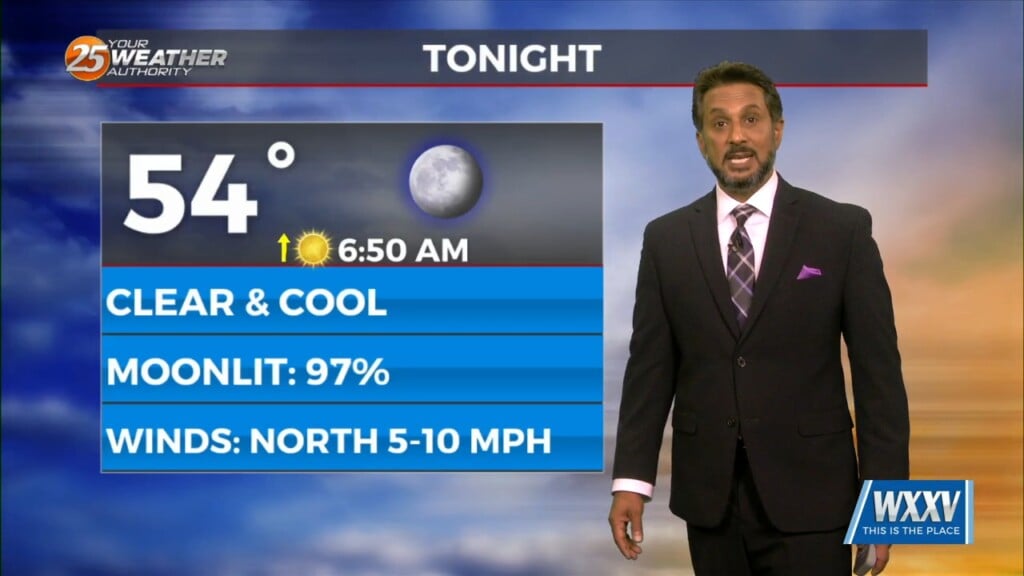
Expect temperatures to drop fairly quickly this evening as winds relax and skies remain mainly clear. It will be chilly if you have any remaining Mardi Gras…
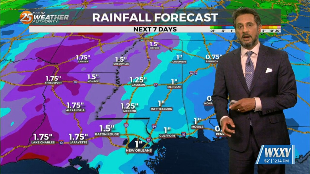
High pressure will continue to build into the region from the west as the low pressure that gave us rain/hail on Sunday continues to move…
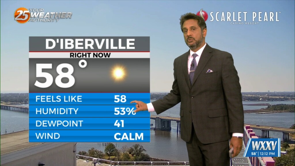
Winds will start to come around to southerly today for most of the area. This will help transport some moisture to the area but not enough for…
A reinforcing shot of dry air has started moving into the area. A back door cold front has moved into the N’tern GOM and…
A much drier air mass in the wake of an overnight cold front will remain in place through Thursday. The next reinforcing shot of dry air…

A dry air mass will remain in place through Wednesday. The next reinforcing shot of dry air will move down behind a new backdoor cold front…
The main focus is once again on the possibility of a light freeze in areas that may not have experienced a freeze, then on the…
It will be cold again tonight with low temperatures below average. That being said, some clouds moving in will limit temperatures bottoming out. You will still need to…
Temperatures will sharply drop this evening, but may not bottom out at their maximum potential overnight thanks to cloud cover moving into the region. Mid and…
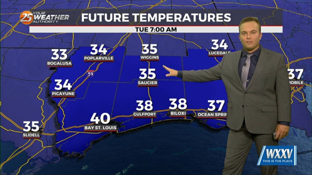
Tuesday will be a frigid start with a reinforcing shot of colder air making its way through the area. There will also be a slight wind…
Temperatures will plummet this evening as a secondary cold front will make its way through the region. Winds will pick up somewhat overnight which may offset the…
The region will remain under a mostly dry northwesterly flow aloft today. Overall, temperatures will remain right around normal with most of the region climbing into…
It will be cold again overnight but frost concerns should be very isolated. Your Wednesday will feature upper-level clouds streaming in leading to a few clouds…
Temperatures will be cool this evening but winds will back off gradually. Skies will be mostly clear which will help it turn cold in a hurry…