Night Rob’s “100 Degrees Could Come Back” Sunday Night Forecast
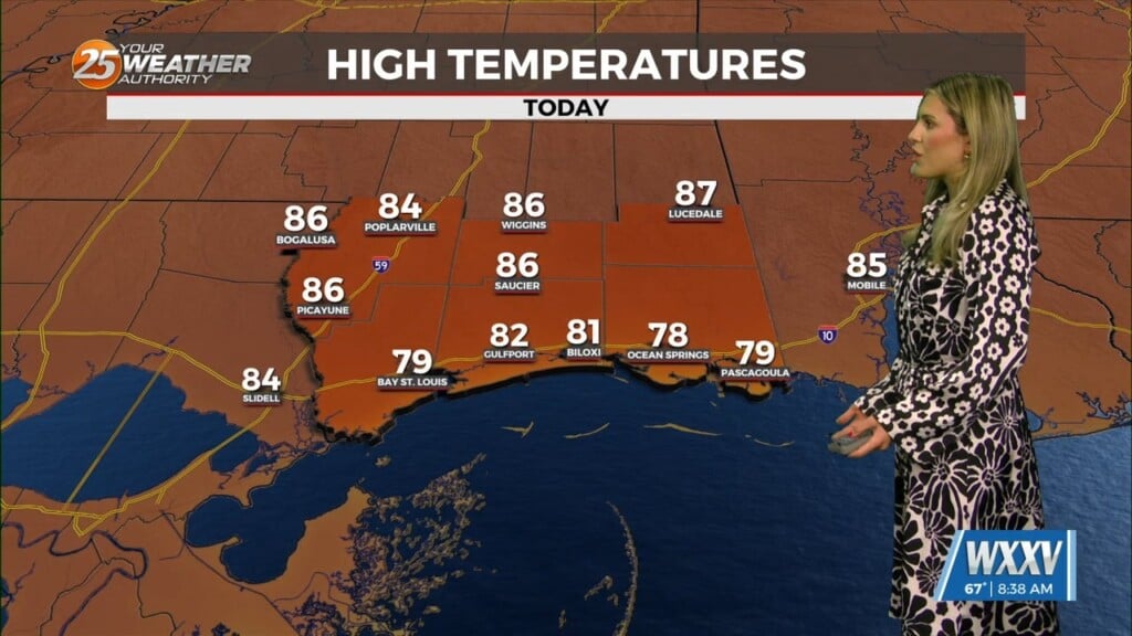
It remained hot out there today, with temperatures generally in the lower and middle 90s. The one difference for most of the area is that relative humidity values are 20 percent lower today, keeping heat index values closer to 100 today than to 110. The exception locally was around Bay St Louis, where the muggy air hung on with a real-feel of 110.
Monday and Tuesday won’t be too different from today, as the temperature/humidity combo should keep us under heat advisory numbers. We’re going with a 20% chance of isolated weak storms Monday.
Looking at current forecast solutions indicate if there`s a day that will be less hot than the others, it`ll be Tuesday, but even then, we`re only talking a degree or two. We`ll be right back to the blast furnace Wednesday with temperatures approaching 100 degrees across most of the area, at which time heat advisories are likely to start again. High pressure will be close enough to quell any significant storm chances through the work week.
The end of the week will be flat out hot again. Beyond Friday, humidity bumps up further, continuing the dangerous heat into next weekend, with little or no relief until perhaps the 27th-28th. The increased humidity will allow for a 20% chance of storms next weekend but that’s about it. On another note, we are falling behind on rain again, and this heat is only increasing the need for relief in that regard. Officially at the Gulfport/Biloxi location, rainfall is down over 7 inches on the calendar year. Consecutive 100+ degree days in June are almost unheard of in our area, but forecast analysis is painting that possibility at the hotter spots from Wednesday through next weekend.