Thursday Night Forecast
Warm temperatures continue
Warm temperatures continue
Thursday Night Forecast
A sunny and mild start with a warm day on-tap...
Hot and humid
Nice weather for Thanksgiving
A mild start, with a few t-storms over the sound...
Hot and sunny weather continue

Expect a few hot and dry days ahead.
Light fog this morning with a few t-storms this afternoon...
Warm week ahead.
Beautiful weather ensues after the extreme weather
Hot and humid weekend

Showers could be headed our way
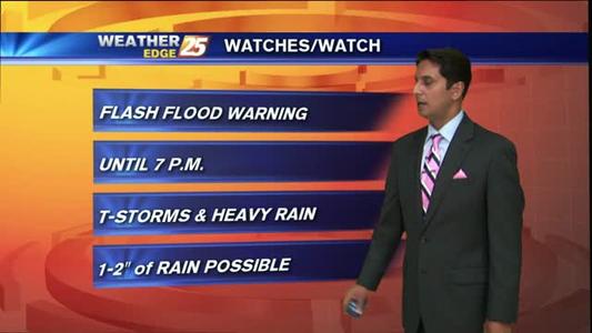
Isolated T-Storms early on this Friday morning...
Chance of an afternoon shower for Friday
Showers and thunderstorms are on the way.
Calmer weather moves in for the rest of the week.
Warm temperatures sticking around.
Finally...a storm-free start to the day...
Thunderstorms expected Wednesday

Slight chance of afternoon showers the rest of the week but expect a cooling trend as well.
Thunderstorms moving through the area early this morning...
Thunderstorms continue
Great looking forecast for Thanksgiving day.