Tropical Storm Isaias continues to strengthen, track shifting east
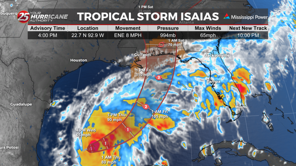
Tropical Storm Isaias has maximum sustained winds of 65 mph and is moving east-northeast at about 8 mph, as of the 4 pm advisory from the National Hurricane Center.

The storm is expected to turn toward the northeast and then north Thursday into Friday before making landfall along the northern Gulf Coast late Friday or early Saturday.
While the forecast cone has shifted slightly to the east, it is still too early to let your guard down completely, especially those in Jackson and George Counties.


A Hurricane Watch is now in effect from Bay St. Louis, Mississippi, to Indian Pass, Florida.
A Storm Surge Watch extends from the mouth of the Mississippi River to Yankeetown, Florida.
These watches do not mean those impacts are guaranteed, but they mean conditions could become dangerous as this storm approaches and preparations should be underway.

Storm surge is one of the biggest concerns along the coast. The latest forecast calls for the potential for 5 to 7 feet of water above ground from Ocean Springs to the Alabama state line, if the peak surge occurs around high tide. From Bay St. Louis to Ocean Springs, 3 to 5 feet of storm surge is possible.

Rainfall will be highly dependent on the storm’s eventual track and where the heaviest rain bands develop. The heaviest rain threat will likely stay to our east, provided the storm stays to the east. Any wobble westward could increase rain amounts across parts of South Mississippi.
Areas that receive the heaviest rain could see flash flooding, urban flooding and some river flooding. Low-lying areas, poor drainage locations and places that receive repeated bands of heavy rain will be particularly vulnerable.