7/27 – Rob Martin’s “Rain Chances Ramp Up” Wednesday Evening Forecast
A stagnant summer pattern has set up this week, with rain chances dependent upon an oscillating high pressure area and variations in the daily sea breeze. Areal coverage of storms was pretty sparse today, but is likely to ramp up Thursday and Friday. Very moist air along with erratic thunderstorm development thanks to sea-breezes and the like could run into a similar issue as yesterday where intense rates of rain could cause some localized flooding in a few spots before shutting off again around sunset. This will be the case through the rest of the work week. As for the heat, real-feel temperatures could reach 108 degrees (criterion for a heat advisory) in the hottest spots at times this week, but no advisories are likely because it’s simply not widespread enough.
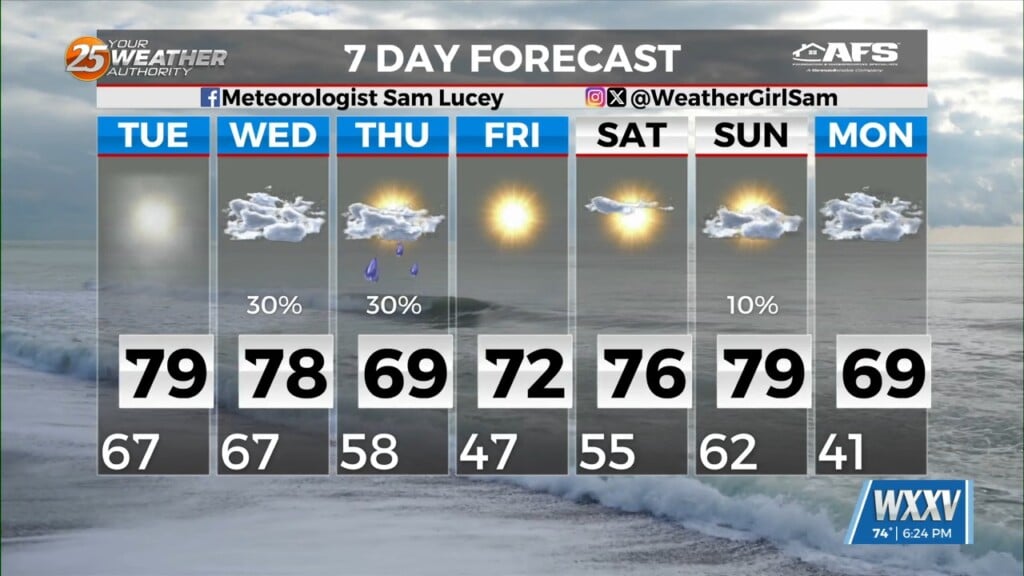
Current rain chances remain 20-30% this evening, but increase to 50-60% Thursday and Friday along with a bit more cloud cover. This is due to an easterly wave forecast to swing through at that time.
The high pressure should build back in west and northward and generally rain chances will go down some back into the 30% range for the weekend. This will bring back in some of the warmer temperatures again. These temperatures at least will be around what is normal for this time of year in the area. Heat advisories might be needed again next week depending on how strong the ridge will build back in, as some mid 90s are possible by next Tuesday or Wednesday.