3/26 – Sam’s Thursday Night Forecast
Meteorologist Sam Lucey has a look at the week ahead
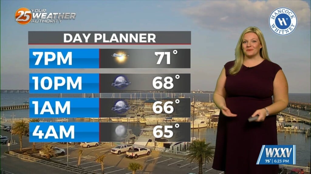
Fog will be the main issue heading into Friday morning, with areas of dense fog becoming more likely after 5 a.m. and lingering through mid-morning. Visibility may be reduced at times, so plan for slower travel during the early morning hours. Aside from the fog, tonight stays mild with partly cloudy skies and lows in the lower 60s.
By Friday afternoon, conditions improve as clouds gradually clear and temperatures warm into the low 80s. A light southwest breeze will pick up later in the day, making for a warmer and more humid finish to the workweek. Skies turn mostly clear Friday night with a cooler low near 60 as winds shift to the north behind a cold front.
Sunshine returns Saturday, but it will be breezy with north winds gusting up to 25 mph, helping bring slightly cooler air with highs in the mid 70s. We do have a Fire Weather Watch in effect for Saturday, although it could be upgraded to a warning by Friday evening. Clouds increase again on Sunday, keeping temperatures in the low 70s with an easterly breeze.
A slight chance of showers develops Monday afternoon, followed by better chances for scattered showers and thunderstorms Tuesday into Wednesday.