12/21 – Brantly’s “Fog Overnight, A Few Clouds Tomorrow” Monday Night Forecast
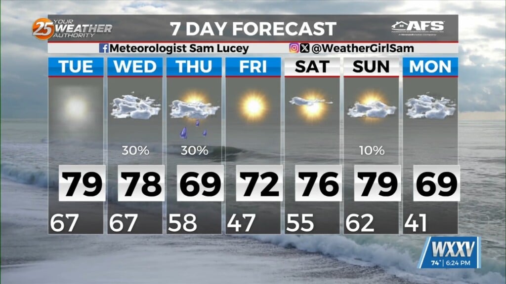
Expect one more chilly night tonight with temperatures bottoming out around normal for this time of the year with lows in the upper 30s and lower 40s for inland areas and in the mid 40s to lower 50s farther south along the coast.
As high pressure shifts eastward Tuesday, expect winds to veer to the east and then eventually southeast, leading to a moderating trend. Lows tomorrow night are expected to be around 10 degrees warmer than tonight in most places.
By Wednesday, an upper-level low pressure system will be digging into the Texas, and forcing a surface cold front eastward ahead of it. The front should push through the local area during the late afternoon through the first part of the overnight hours, so rain chances are elevated at about 80 percent Wednesday night into Thursday morning.
Regarding impacts along the front, severe weather doesn’t look like too much of an issue given the very limited instability and the fact the surface low will be so far removed to the north, but stranger things have happened along the Gulf Coast, so it can’t be ruled out entirely at this point.
Cold air comes rushing in behind the front for a chilly Christmas Eve and Christmas Day. Highs on Thursday and Friday will struggle to reach the 50 degree mark in some places, and the forecast may need to be adjusted downward even more on Thursday. It will feel especially Thursday when the brisk wind is factored in as well. Wind chills through much of the day will be in the mid 30s to mid 40s depending on location.
As winds die down Thursday night, temperatures will plummet leading to a literally freezing Christmas morning for much of the area. Lows are currently forecast to drop into the upper 20s to lower 30s north and into the mid 30s to lower 40s south. All in all, it should be our coldest Christmas in several years, possibly back to about 2013.
A gradual moderation begins Saturday but really kicks in on Sunday as yet another front approaches the area. Currently the timing of the next front looks to be late Sunday into Sunday night but there are still some timing and intensity differences between the major models and their ensemble members.
Leave a Reply